The Kamitsue Project
Highlights
- The Kamitsue property is located 10 km southeast of the Taio mine in the Northern Kyushu Epithermal Province. The Taio mine, northern Kyushu’s largest gold mine, produced approximately 1.2 million ounces of gold at an average grade of 6.3 g/t between 1903-73 (1Garwin, 2005, 2Shikazono, 1986). Kyushu hosts two other plus million-ounce gold producers, the currently producing Hishikari mine with 6 million ounces of gold produced to date at average grades of 30-40 g/t Au (Sumitomo Metal Mining Co. Ltd. website) and the Kushikino mine which produced 1.8 million ounces of gold at a grade of 6.7 g/t between 1914-74 (1Garwin, 2005, 2Shikazono, 1986) in the southern part of the island.
- At least 40 mine portals and associated workings from the pre-WWII era are noted within the property (3Watanabe, 2005), however no gold production records have been sourced to date.
- The Kamitsue Project contains a single large epithermal, advanced argillic alteration (AAA) lithocap.
- The Kamitsue lithocap may have formed above a telescoped porphyry system. Based on the mapped alteration and metal zonation patterns interpreted by Japan Gold’s consultants, the causal porphyry intrusions associated with the Kamitsue lithocap are interpreted to lie 0.5 km depth below the present-day land surface.
Project Details
The Kamitsue Project comprises twelve (12) contiguous Prospecting Rights blocks (4,069 Ha) near the town of Kikuchi in northern Kuyshu. A large east-west oriented area of clay alteration and geochemical anomalism with localised quartz veining was identified by the MMAJ during regional metallogenic and follow-up prospect-scale surveys in the 1990’s across the project area.
History
No known historical gold production records exist for the pre-WWII era Kamitsue mine workings however Wantanbe, 20053 notes the presence of at least 40 mine portals and associated workings.
Exploration was undertaken from 1990 to 1992 by MMAJ as part of a regional metallogenic study which included regional gravity surveys, surface sampling (semi-regional and prospect scale), culminating in scout diamond drilling. Chronologically this included:
1984: Sumitomo geological sampling of historical mining portals.
1990: Geological mapping, geochemical sampling (300 rock chip samples) and alteration mapping.
1991: Prospect-scale rock chip sampling (399 samples) collected. This and previous work identified two distinct coincident clay-alteration / geochemical anomalies including a 5.5km by 1.5km east-west trending zone with anomalous gold, silver, arsenic, antimony and mercury and a smaller 1.5km by 0.5km zone with anomalous gold, silver, arsenic and mercury. A single inclined drillhole (3MAKC-5, 400m depth) targeted a Au-Ag-As rock geochemical anomaly and intersected a 1.6 m wide quartz vein zone which assayed 0.12 g/t Au & 11.1 g/t Ag from 341.9m (4METI, 1991).
Geology and Mineralisation
The majority of the property is underlain by Neogene andesite intrusions with volcanic equivalents including lavas, tuffs. Dacitic equivalents are found in the upper part of the sequence. Unconsolidated quaternary volcanic tuff deposits occur as a thin veneer occupying topographical highs.
Spectral mapping has noted the presence of magmatic-hydrothermal advanced argillic alteration (AAA lithocap), including K-alunite, pyrophyllite-diaspore, zunyite, dickite and kaolinite occur in several occurrences over an area of about 1.5 km diameter, in the eastern half of the property. The largest zone of advanced argillic alteration is about 950 x 550 m in area, oriented NW and zoned outward to paragonite, and chlorite alteration zones.
Sporadic and coarsely crystalline low sulphidation (“LS”) epithermal vein mineralization is hosted by an argillic alteration assemblage of illite-sericite-carbonate-pyrite-marcasite with strong E-W structural control. MMAJ and Sumitomo describe LS epithermal mineralization as a series of sub vertical quartz-carbonate-pyrite+marcasite veins and veinlets, with crystalline, banded & drusy textures along with minor amounts of disseminated base metal sulphides (sphalerite/galena/ chalcopyrite).
Sampling by 5Sumitomo (1982) of historical mining portals reported values of <0.01-6.0 g/t Au and <0.5-6.0 g/t Ag, whilst MMAJ sampling in 1991-92 returned values of 0.001-0.33 ppm Au, 0.1-1.96 ppm Ag, 1-63 ppm As, 1-33 ppm Sb, 0.05-1.76 ppm Hg & 1-262 ppm Mo.
Exporation
SAMJ to date has conducted only preliminary traverses, literature reviews and data searches on the property. An independent consultant team in April 2018 completed preliminary alteration mapping over the property as a series of traverses across documented alteration zones in conjunction with closely spaced sampling. The work program included:
- SWIR spectrometer alteration survey (Plus Minerals) – 157 spectral analyses;
- Surface rock geochemical survey – 142 gold and multi-element analyses (ALS);
The Kamitsue lithocap is exposed over an area of about 950 x 550 m, oriented NW and corresponds to a high hill with 750 m elevation. Discrete domains of silica-K alunite with weak vughy silica alteration locally occur along the ridge top and are surrounded by a wide zone of pyrophyllite±diaspore alteration at lower elevations. Selective grab samples across the lithocap show a strong coincidental Mo-Bi±Se±Te geochemical signature typical of a intermediate to higher levels of a porphyry system.
Sampling of alteration outliers to the main AAA lithocap reported elevated values of 0.58 g/t Au/11.05ppm Mo and 0.14g/t Au/523ppm Mo respectively.
A swarm of E-W and WNW-ESE trending, crystalline LS epithermal quartz veins to the WNW and NW of the AAA lithocap zone returned low to moderate tenor values ranging from <0.1-2.17 g/t Au and <1-16.2 g/t Ag.
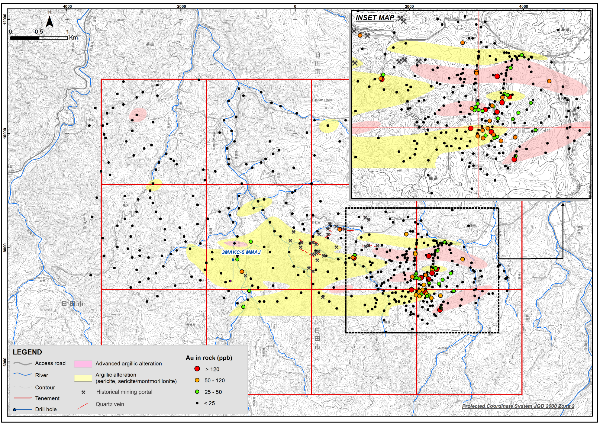 Kamitsue anomalous rock gold geochemistry and alteration zones (MMAJ, 1992)
Exploration Potential
The potential for porphyry mineralization below the AAA lithocap is seen as the primary target at Kamitsue. As the lithocap is interpreted to have eroded below the vuggy silica-alunite zone, porphyry mineralization if present, could be expected at approximately 500 m below surface.
This is supported by alteration and coincidental metal zonation patterns typical of an intermediate to higher levels of a porphyry system
References
1 Garwin et al. 2005. Tectonic setting, Geology, and gold and copper mineralization in the Cenozoic magmatic arcs of Southeast Asia and the West Pacific. Economic Geology 100th Anniversary Vol. pp 891-930
2 Shikazono, N. 1986, Ag/Au Total Production Ratio and Au-Ag Minerals from Vein-Type and Disseminated-Type Deposits in Japan, Mining Geology, 36(6), p 411 – 424.
3 Watanabe, 2005. Late Cenozoic evolution of epithermal gold metallogenic provinces in Kyushu, Japan. Mineralium Deposita (2005) 40: pp 307-323
4 METI, 1991-1997. Reports completed by MITI on the Takamine area (Years 3 to 9). The Agency of Natural Resources and Energy of MIT.
5 METI (1984- 1989): Report on the regional survey of the Hokusatsu-Kushikino region, Showa 58 (FY) to 63(FY). Ministry of International Trade and Industry.