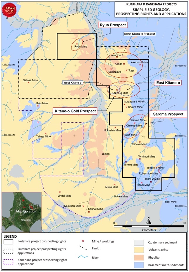
The Ikutahara Project
Overview
| Commodity: | Gold |
| Target: | Low Sulphidation Epithermal Gold |
| Location: | Northern Hokkaido |
| Size: | 20,513 hectares |
Project Detail
The Ikutahara Project is the Company’s most advanced project and comprises 60 prospecting rights applications. All applications have been accepted by the Japanese Ministry of Economy, Trade and Industry (METI). Thirty eight of the 60 applications have been converted to Prospecting Rights, allowing for more advanced forms of exploration including drilling.
Japan Gold is currently applying for drilling permits on the Kitano-o and Ryuo prospects within the Ikuthahara project. The project covers 17 historical gold mines and workings. These prospects were discovered and intermittently mined between 1910 and 1943. The project area has seen only limited exploration since that time.

Prospectivity
Japan’s third largest gold mine, Konamai, which operated between 1917-1974 and produced over 73 t or 2.3 Moz of gold at an average grade of 6.4 g/t5, is located along the same geological trend 20 kilometers northwest of the Ikutahara Project. The most significant historic gold production in Japan Gold’s Ikutahara project came from the Kitano-o mine (1924-43), reported to have produced 96,450 ounces at a grade of 5.9g/t5 of gold largely from the mining of gold-bearing eluvium associated with sinter deposits and sub-sinter epithermal veins. Lesser gold production is reported from selective hard rock mining of sub-sinter, and volcanic-hosted quartz-adularia-clay veins and stockworks both in, and around the Kitano-o mine area10. Production records sourced for the Ikutahara and Showa mines include the following:
Kitano-o Gold District – Historic Gold-Silver Production Record4.
|
Mine |
Tonnes |
Gold g/t |
Silver g/t |
Operating Years |
Source |
|
Ikutahara |
96,812 |
5.2 |
40.6 |
1934-1943 |
MMAJ, 1990 |
|
216 |
35.6 |
Not recorded |
1960-1961 |
MMAJ, 1990 |
|
|
Showa |
12,323 |
16.8 |
7.8 |
1934-1943 |
MMAJ, 1990 |
Regional setting and metallogeny
The Ikutahara Project lies in the Southwest Kuril magmatic arc, where Neogene volcanism has been active since the Early Miocene1. More than forty low-sulfidation epithermal gold and mercury deposits and prospects are distributed in northeast Hokkaido within the Southwest Kuril arc.
The project area is underlain by Miocene-Pliocene age volcano-sedimentary rocks, and older meta-sedimentary basement, that are prospective for low sulfidation-style epithermal gold-silver vein deposits. Multiple gold-silver and mercury prospects including documented mines and workings are located throughout the Prospecting Rights application area, and the majority comprise epithermal veins, associated with other hot-spring related features such as silica sinter, hydrothermal breccias and widespread hydrothermal alteration.
2017-2019 Work program
Japan Gold has completed a compilation of all available published historical data on the gold mines and mineral occurrences present in the Ikutahara project area. Exploration field activities comprised first pass to detailed geologic mapping and sampling over the majority of the epithermal gold targets. The Company is currently developing high-priority drill targets at Ikutahara, specifically in the Kitano-o Gold District and historical Ryuo mine areas. The main focus being in and around the historic mines and workings, with the aim to rapidly progress these targets through the permitting phase so that they can be drill tested.
2017 Drilling
A drilling permit was granted, and the Company's first scout drilling program was completed at the Akebono prospect in December 2017. Initial drilling results support the presence of high-grade gold shoots in the Akebono vein system previously indicated by historic sampling of underground workings. Complete results can be found in the news release dated February 5, 2018
2019 Phase 1 Drill Program
Phase 1 drill testing of the western side of the Kitano-o Prospect was completed in late December 2019 with 6 diamond drill holes, totalling 2,837 metres. Drilling targeted depth extensions of the western end of a well-defined vein-corridor exposed within extensive shallow open-pits and geophysical anomalies (see February 19, 2020 news release for more information)
2020 Exploration Plans
Based upon the results of Japan Gold’s review of available literature and data, validation by its own in-house field programs and results of preliminary scout drill programs in 2017 and 2019 additional Phase 1 drilling programs are planned in 2020-2021. Continued development of other target areas will include grid-based soil sampling, associated rock geochemistry and geologic mapping, along with ground CSAMT geophysics. Prospect-scale activities will be focused on the Kitano-o East and North Kitano-o (Sakinzawa, Asada Ridge & Toge Ridge) areas.
2021-2022 Work Programs
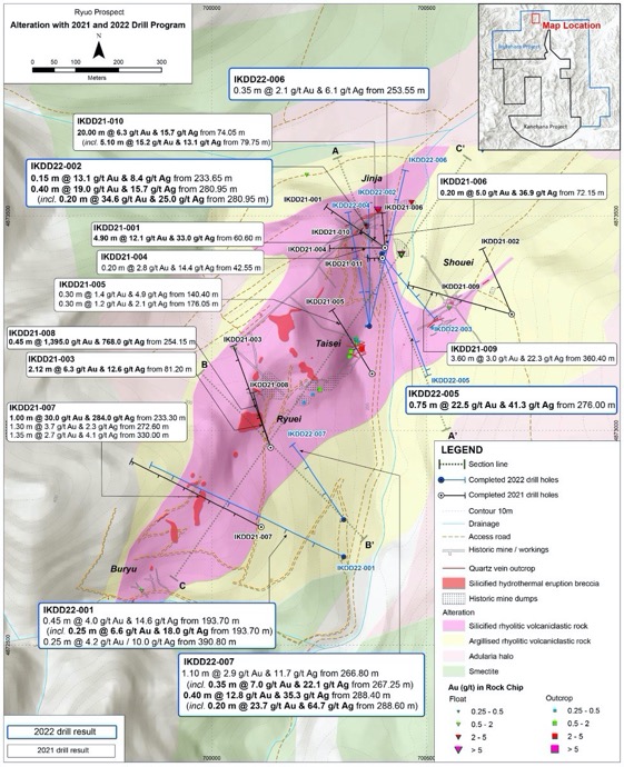
High-grade gold-silver veins were intercepted in its first drill holes at the Ryuo Prospect, within the Ikutahara Project. The initial drill holes at Ryuo have confirmed wide, high-grade vein mineralization is continuous below the historical workings closed in 1943 (see September 14, 2021 news release for more information).
Following the success of the three initial scout drill holes, additional eight scout drill holes at the Ryuo prospect have continued to encounter high-grade vein intersections along an 800 m open ended strike zone (see February 22, 2022 news release for more information).
Seven additional drill holes at the Ryuo prospect have continued to encounter high-grade veins along the Ryuo alteration corridor, and interpretation of drill core has significantly advanced the understanding of controls on mineralization at the prospect. High-grade gold events have been identified along the length of the prospect in multiple parallel vein zones, and alteration studies prove the system is well preserved (see October 11, 2022 news release for more information).
Eleven new prospecting rights were lodged to cover prospective Miocene volcanics immediately to the north and west of the Ryuo prospect to ensure coverage of potential strike and parallel extension to the Ryuo mineralization.
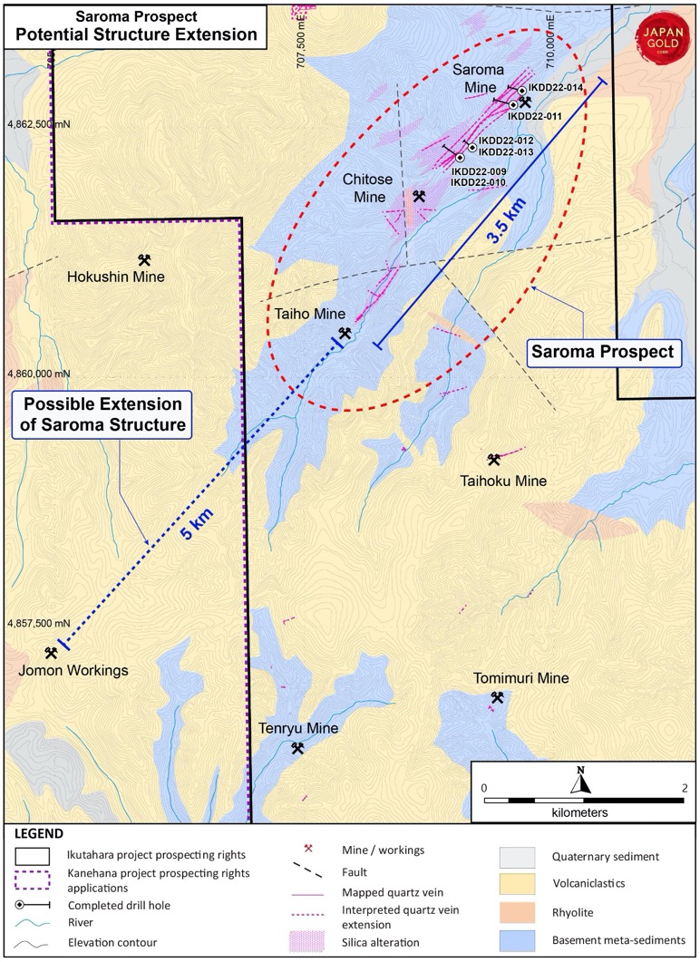
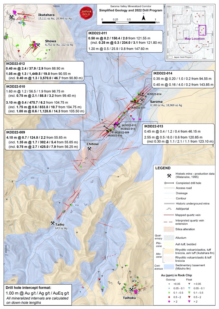
Drilling at the Saroma prospect has encountered multiple intersections of high-grade silver with gold mineralization along a 1 km length of the Saroma vein. The Saroma vein forms part of a larger, 3.5 km long open-ended district-scale mineralized structure which hosts the Saroma, Chitose and Taiho historical workings, collectively called the Saroma prospect (see December 14, 2022 news release for more information).
Key Prospects
Kitano-o Gold District
The Kitano-o Gold District comprising the Kitano-o, Ikutahara, and Showa mines and Sakinzawa workings, is underlain by a thick sequence of rhyolitic volcaniclastic rocks intruded by rhyolite-dacite flow domes, dykes and lavas10 2. These are part of the Late Miocene Ikutahara Formation which occurs in a 10-km wide, north-south trending basin known as the Monbetsu-Rubeshibe zone. These basin-fill rocks unconformably overlie meta-sediments of the Upper Cretaceous-Paleocene Yubetsu Group exposed to the east of the mine area and intersected in a 1990 MMAJ drill hole at about 700-m vertical depth below the Kitano-o mine1 4. Epithermal gold-silver mineralization in the Kitano-o-Ikutahara-Showa mine areas is closely related to the emplacement of the Maruyama Rhyolite dome, during sedimentation of the Ikutahara Formation10.
History
The historic Kitano-o Gold District comprises four known historic eluvial and hard rock gold mines and workings: Kitano-o, Ikutahara, Showa and Sakinzawa over an approximate 6 by 2.5-kilometer area. The district is highlighted by an extensive co-incident gold-arsenic-antimony mercury anomaly in stream sediment samples over the area.
MMAJ (Metals Mining Agency of Japan) conducted exploration over the Kitano-o Gold District and surrounding area as part of a metallogenic study of the region in the late 1980’s. Their work included geological mapping, gravity and CSAMT geophysical surveys, a low-density regional soil geochemical survey, petrological studies, age dating and culminated in the drilling of two vertical diamond holes testing geophysical targets.
The MMAJ work defined a large shallowly eroded epithermal system encompassing the Kitano-o Gold District, documented a close relationship between gold mineralization and rhyolite intrusions and provided valuable information on the depth to basement rocks (up to 700 m).
Historic production from Kitano-o (96,540 ounces at a grade of 5.9 g/t)5was largely from rich residual surface gold deposits (gold-bearing eluvium). Lesser gold production is reported from selective hard rock mining of narrow sub-sinter quartz-adularia-clay veins and stockworks hosted in extensively altered rhyolitic volcaniclastics, flow-domes, lake sediments and silica sinter deposits.
The workings at Kitano-o are represented by numerous shallow diggings, pits, sluicing benches, and collapsed tunnels distributed over a 2.5 by 0.4 kilometer east-west alignment of altered conical hills and curve-linear ridges. The hard rock workings at Ikutahara and Showa, at the southern end of the Kitano-o Gold District, are defined by a series of collapsed tunnels and large mine dumps distributed along a north-northwest trending ridgeline.
Kitano-o historic reports3 4 10 indicate that free gold was won from rich eluvial placer deposits described as a yellow-brown clay-sand-boulder soil overburden (“Dosha-ko” ore). The auriferous eluvium averaged about 5 m thickness (max. 15 m thick) with a reported gold grade of about 5 g/t Au (max. 40 g/t Au) in the most productive areas. The dosha-ko gold deposits were formed by the disintegration and oxidation of the underlying hydrothermally altered mineralized bedrock under freezing-and-thawing cold-climate conditions (“cryogenic weathering”)3.
Multiple narrow gold-quartz veins (>130) were reportedly worked beneath and surrounding the auriferous eluvium, however, mine records on the depth of mining of the veins is sparse. The veins varied in width from <1 to 30 cm and thicker mineralised veins were only rarely encountered. Strike-lengths varied from several metres to several 10’s of metres and veins longer than 100 m were rarely encountered. Several types of mineralised epithermal veins were reported in the district: banded quartz-chalcedony-adularia veins, fine-grained crystalline quartz veins, clay-rich veins and a late-stage porcellaneous clay veins3 4.
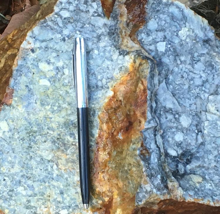
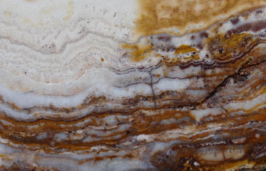 Banded quartz-chalcedony-adularia-limonite vein cobble from historic working immediately beneath the silica sinter deposit (field of view is about 10 cm wide); SAM02175: 3.02 g/t Au, 3.13 g/t Ag, 2.91 ppm Hg, 890 ppm As, 60.5 ppm Sb
The Sakinzawa workings are located at the northern end of the Kitano-o Gold District. Alluvial and colluvial gold was worked along Sakinzawa creek and its broad floodplain during the 1930’s, however, there are no production records. Small hard rock gold workings on quartz breccia and stockworks have also been found along Sakinzawa creek and on the western flank of Maruyama peak, which is a prominent rhyolite flow-dome landform.
MMAJ and the NICAM Joint Venture (Nissho Iwai Corp/Austpac/MIM) carried out exploration work on Sakinzawa creek and Maruyama ridge in the 1990’s. This work included geological mapping, ground geophysics (CSAMT), trenching, RC drilling and one diamond drill hole by MMAJ.
Trenching in Sakinzawa creek exposed a 100m x 300m zone of silicified, brecciated and quartz veined mudstones and rhyolitic volcanic rocks beneath shallow colluvium and returned highly encouraging channel-chip results including 9 m at 24 g/t gold and individual 1 meter samples ranging from 15 to 109 g/t Au8.
The 300 m vertical diamond hole (2MAHB4) drilled by MMAJ on Maruyama ridge intersected silicified mudstone-sandstone-volcanic breccia to 140 m depth containing minor narrow quartz veins assaying up to 2.3 g/t Au4. This is a useful stratigraphic hole but a poor test of the gold target.
Showa and Ikutahara prospects contain historic workings developed on epithermal veins and disseminated-stockwork zones at the southern end of the Kitano-o gold district. Small-scale underground gold production at Showa occurred between 1934 and 1943 at an estimated average gold grade of about 17 g/t Au 4.
The Ikutahara lode system strikes ENE-WSW to E-W, with lesser branching veinlets developed in more N-S orientated fracture sets. The mineralised corridor exceeds up to 700 m in strike length, and is characterized by veinlets or stockworks with individual strike lengths of 20-30 m and widths of 1-20 cm. The variation in Au values across the prospect is reportedly “extreme”, however on average, a higher tenor of mineralisation is observed associated with an increase in adularia content and/or at higher elevations2 4. Supergene weathering and enrichment is also suspected to influence primary gold values. Ore minerals include native gold, argentite, cinnabar and pyrite, whilst gangue comprises quartz, adularia, calcite and kaolinite7.
The Showa lode system trends primarily WNW-ESE to ENE-WSW, and dips steeply (70-90°) to the north or south over an approximate strike length of 250 m. Individual veins have a maximum width of 2.0 m. Branching fracture-controlled quartz veinlets trending NNE are described to form bonanza zones at their intersection with larger WNW-ESE quartz vein structures. Au values reportedly vary, or are more erratic in the larger veins, and are more consistent in veinlets4 7.
Japan Gold 2017-2019 work program
The Kitano-o Gold District is highlighted by the largest coherent geochemical anomaly returned from the 2016 SAMJ stream sediment survey, with a coincident Au-As-Sb-Hg anomaly defined over a 5-km by 2-km area centered on Kitano-o. (refer to the Company’s website news release dated March 3, 2017.
Numerous historical gold workings have been identified along the east-west Kitano-o mine trend in the latter half of 2017. Mapping defined a +2.5 km-long, by 250-400m wide east-west oriented zone of resistive silica-adularia/clay-limonite altered, volcaniclastic rocks and silica sinter (the latter largely as residual boulders). Outcropping and stockpiled colloform-crustiform and lattice-blade textured chalcedony-quartz veins and quartz sealed hydrothermal breccias, some of unresolved width, and associated stockwork veining, are widespread.
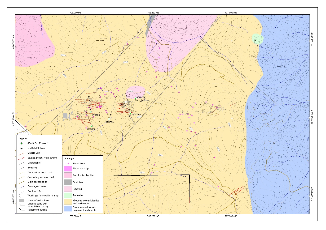 Interpretive geology for the Kitano-o mine area (adapted from Bamba & Saito, 1956) with present day and historical mine workings based on recent surveying and published MMAJ (1990) data
The historic Maruyama Ridge gold workings reported by NICAM and identified during SAMJ’s 2017 mapping, comprise a series of trenches and pits distributed over a 120-m x 100-m area on the ridge crest. Five trenches trending NNE-SSW were recorded; these vary in length from 10-m to 120-m and have exposed a parallel array of mineralised banded and lattice bladed textured quartz-chalcedony-limonite veins and linear-stockwork zones. The workings occur about 500-m north of mineralised stockworked and brecciated outcrops located in Sakinzawa Creek, which were previously tested by NICAM trenching and RC drilling.
Two mineralised zones, located about 300 metres apart along Sakinzawa Creek, were identified during the 2017 mapping and host diffuse thin quartz veins (<1-10mm wide). The outcrops represent small windows of altered and mineralised bedrock exposed within a broad flat riverbed that is largely covered by alluvium.
Mapping and sampling commenced over the Showa and Ikutahara mine areas and included mapping of historic mine entrances and limited rock exposures and sampling of ore and wasted dumps.
Continued surface prospecting and mapping in Q1-Q3 2018 over the historic Kitano-o Gold District (Kitano-o, Ikutahara, Showa mines and the Sakinzawa workings) highlighted the presence of high-grade gold mineralization in grab samples taken from historic mine dumps and workings. Geological and alteration mapping and geochemical sampling is used to develop an understanding of the controls on epithermal gold-vein mineralization. New prospect areas Toge Ridge and Asada Ridge were identified through these prospecting activities and geological modeling.
Surface prospecting of the Kitano-o Gold District continued throughout 2019 with ridge and spur composite soil sampling, geological mapping & rock sampling, along with spectral alteration mapping undertaken over the Sakinzawa, Toge Hill, Asada Ridge and northern extensions of the latter two. To enhance geological modeling and refine drill targeting grid-based resistivity surveys (CSAMT & AMT techniques – 27-line km) were completed over the main Kitano-o prospect in Q4 2019. Similar prospect-scale gravity surveys were completed over the same prospect areas, along with the Toge Hill and Asada Ridge areas in Q3/Q4 2019.
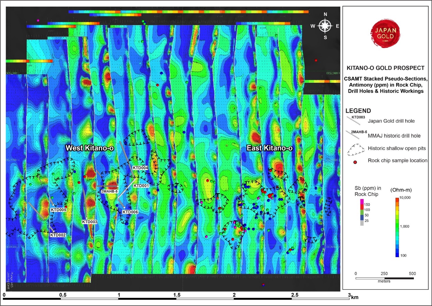 Kitano-o Prospect Stacked CSAMT sections with Phase 1 drill holes and historic surface workings.
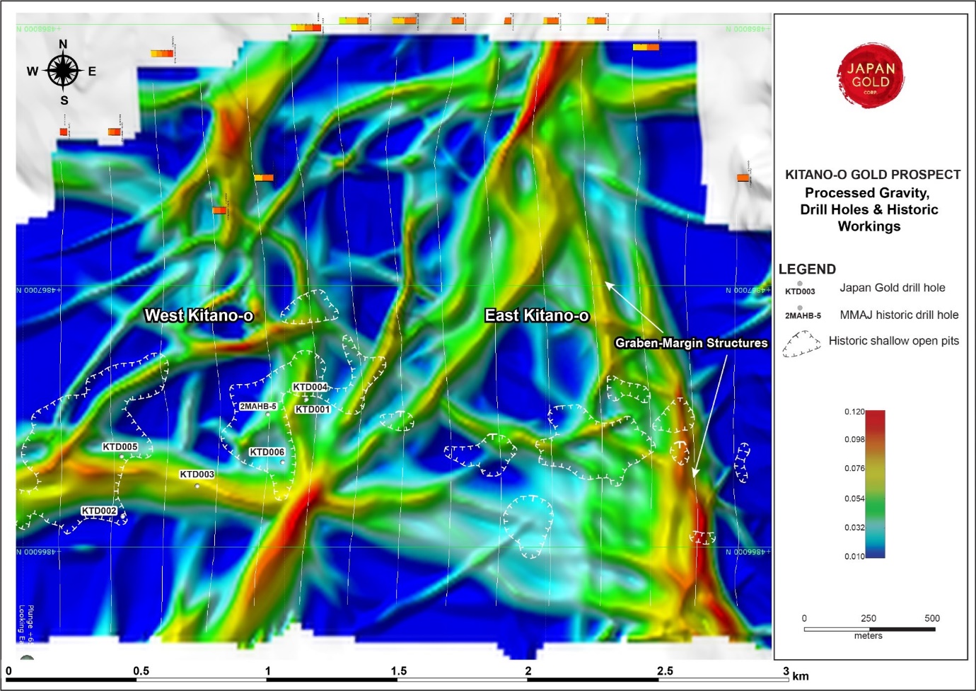 Kitano-o Prospect processed Gravity with Phase 1 drill holes and historic surface workings.
Rock Sample Results Summary (2017-2019)
Assay results have been received for 545 selective grab and chip samples collected from mine dumps, workings and outcrops over the Kitano-o Gold District.
Kitano-o Mine: One mine dump sample from Kitano-o gave a high gold result of 54.4 g/t Au. Eight other mine dump and outcrop samples returned gold results ranging from 1.01 to 8.59 g/t Au. Corresponding silver results are generally low and range from 1.16 to 13.2 g/t Ag.
Of the 75 rock chips collected from east Kitano-o, 16 mine dump samples gave gold assay results greater than ≥2.5 g/t with a peak assay of 60.8 g/t. Quartz vein samples show well-developed colloform-crustiform textures containing bands of disseminated fine-grained black sulphide mineralization, termed 'ginguro'.
Ikutahara Mine: Two mine dump samples from the Ikutahara workings returned high gold results of 37.3 g/t Au and 35.3 g/t Au. Seven other mine dump samples returned gold results ranging from 2.21 to 9.03 g/t Au. Corresponding silver results are generally low and range from 2.71 to 35.5 g/t Ag.
Showa Mine: Five mine dump samples from the Showa workings returned high gold results of 93.3 g/t Au, 36.4 g/t Au, 19.35 g/t Au, 18.20 g/t Au and 17.6 g/t Au. These samples contain visible electrum/free gold disseminated in thin comb quartz veins. Nine other samples returned gold results ranging from 1.31 to 6.39 g/t Au. Corresponding silver results are generally low and range from 1.6 to 22.9 g/t Ag.
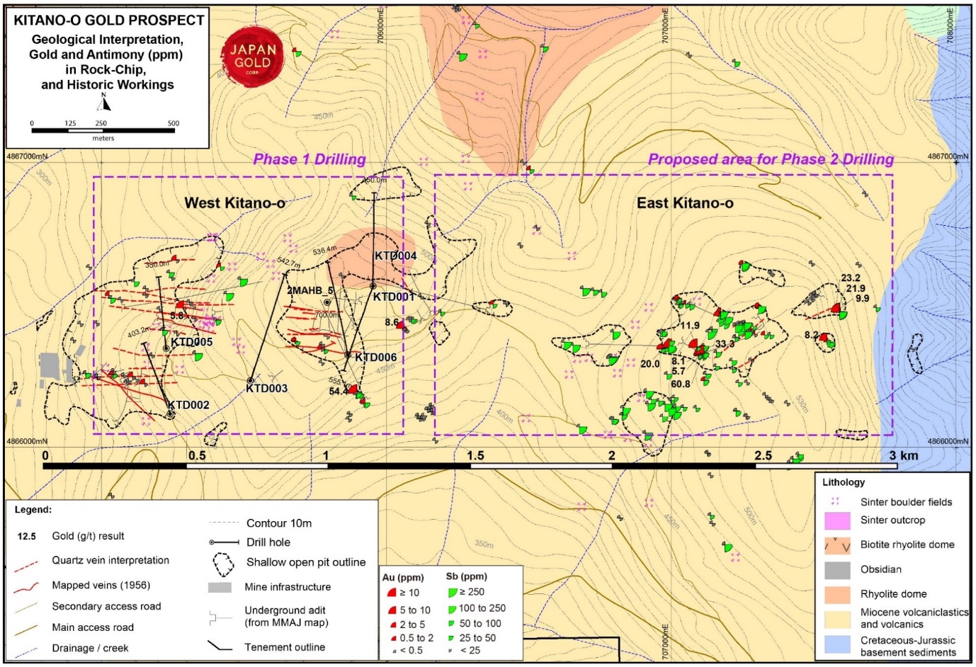 Kitano-o Gold District, Significant Gold Results from Surface Rock Sampling on Simplified Geology
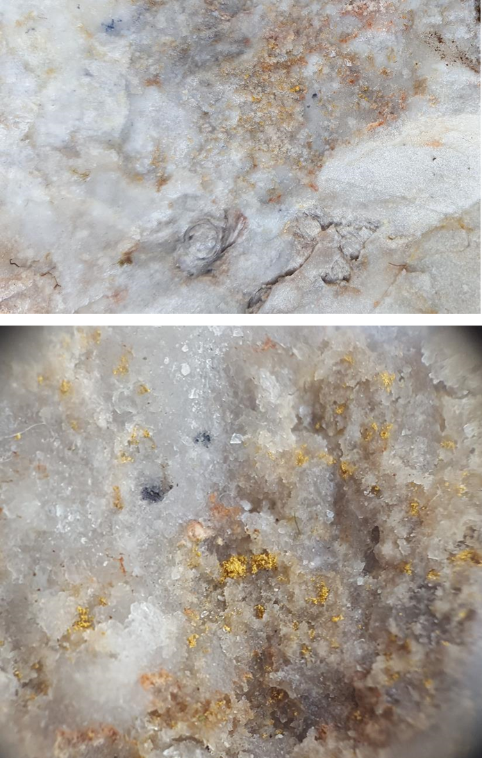 Showa mine dump sample, visible gold and silver sulphosalts in thin quartz stockworks cutting silicified fossiliferous laminated tuffaceous mudstone (top image), bottom image zoomed in field of view is approximately 1 cm; SAM01867: 93.3 g/t Au, 17.35 g/t Ag, 21.4 ppm Sb
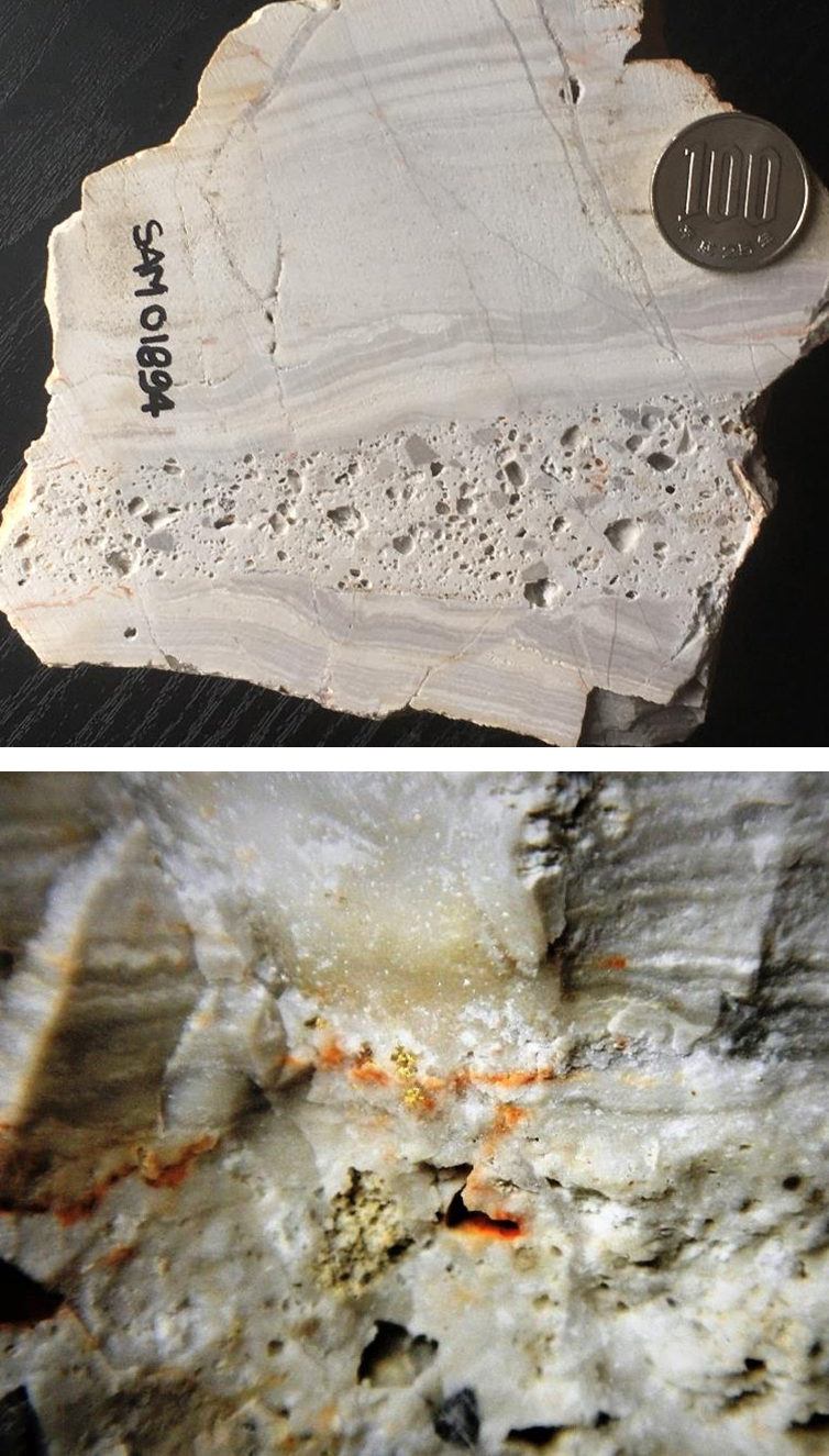 Showa mine dump sample, visible gold in thin quartz stockworks cutting silicified laminated mudstone (top image), field of view in bottom image is about 10 cm; SAM01894: 19.35 g/t Au, 8.49 g/t Ag
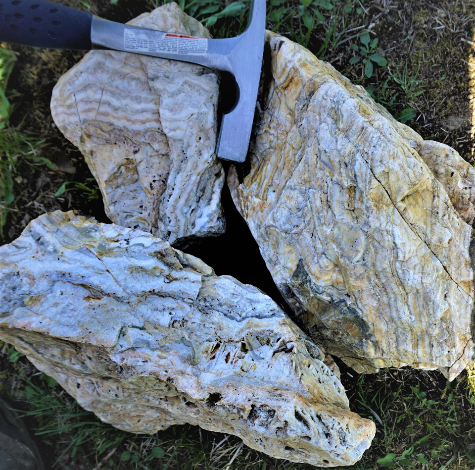
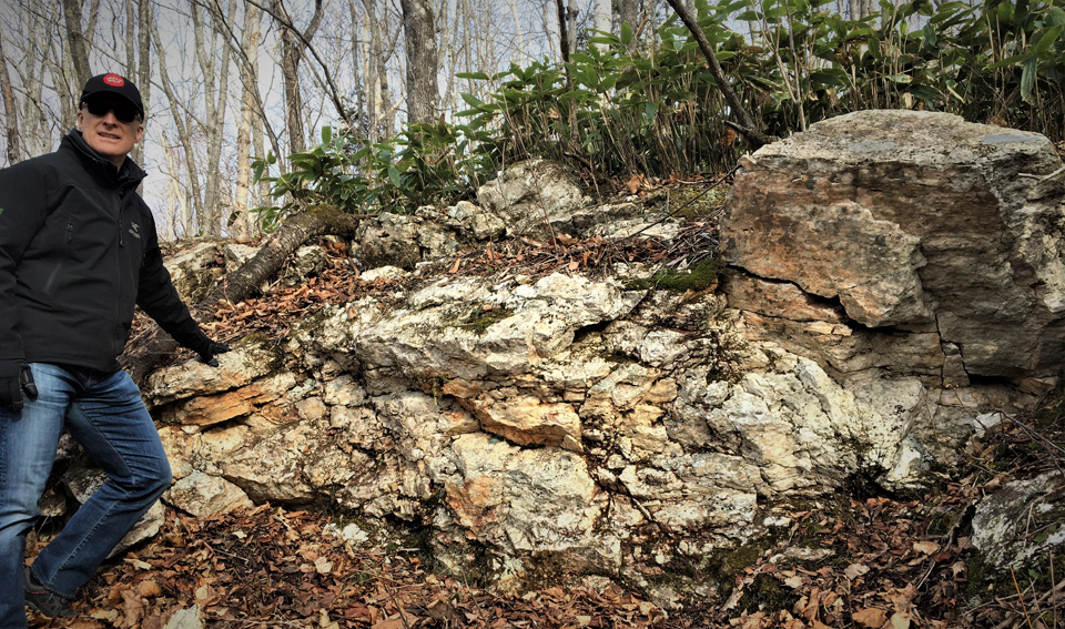 Kitano-o silica sinter outcrop SAM02139: 1.9 ppm Hg, 93.4 ppm Sb, low gold
Alteration mapping by Plus Minerals LLC over the Kitano-o District took place in November 2017, along with on occasions in 2018-2019 (Akebono & Kitano drill core, East Kitano-o and subsequently into Kitano-o North). Preliminary findings and conclusions from these programs include:
- Alteration zonation from surface downward 1. alunite-kaolinite-dickite (steam-heated alteration), 2. silica sinter (paleo-water table), 3. illite-smectite and 4. Illite, the deepest levels sampled at surface. Outward zonation to an illite-chlorite assemblage. This zonation supports the interpretation that the Kitano-o District represents the upper levels of a shallowly eroded, hot-spring gold system
- Widely distributed silica sinter, and deep acid overprinting to depths of 100m at Kitano-o and >230m at Showa, again, indicating widespread hot spring activity. A silica sinter outcrop found at 470 m elevation, marks the approximate position of the paleo-water surface for the epithermal system.
Based on surface geochemistry, CSAMT and gravity geophysics collected over the Kitano-o Prospect, along with the Phase 1 drill hole data, have refined Japan Gold's understanding of the geology of the Kitano-o hydrothermal system and give strong vectors to the eastern side of the prospect. It is now interpreted that the western part of the Kitano-o Prospect represents the 'lateral outflow' of a large epithermal system, developed at depth in the eastern part of the 3-kilometre-long prospect. The eastern side of the Kitano-o Prospect has now been identified as a key target area for Phase 2 drilling. Gold historically mined at surface at the Kitano-o Mine is interpreted to have been deposited at the paleosurface during deposition of a silica-sinter apron through lateral outflow. Silica rich fluids which formed the sinter, also carrying gold, flowed upwards then laterally out from hot spring vents connected to a deep epithermal boiling zone. Rock samples collected in the eastern side of the Kitano-o Prospect show high gold and antimony values potentially indicating higher temperatures of deposition and closer proximity to the 'upflow' or 'boiling zone' where gold was precipitating. The following figure represents Japan Gold's current interpreted geological model for the Kitano-o Prospect.
Geological-wise drilling confirmed the presence of a large, up to 200-metre-thick rhyolite flow-dome complex high in the stratigraphy. The flow-dome is coherent and flow-banded in its core, with complex brecciated margins. The rhyolite dome thickens to the east and north towards the outcropping Maruyama dome, a prominent circular hill located NE of the drilled area. A sedimentary marker horizon underlying the rhyolite has been intersected at a similar elevation in all drill holes. The upper brecciated margin of the rhyolite flow-dome and thin veneer of overlying breccia and volcanic sediments, host an up to 100-metre-thick zone of horizontal, water-table controlled silicification which was intersected immediately below the sinter in all drill holes. CSAMT has also mapped this horizontal-tabular silicified zone at western end of the Kitano-o Prospect. Like the dome itself, this alteration zone thins to the west and south, and appears to map outflow of the hydrothermal system in these directions. The bulk of the mineralised structures intersected in the drill holes occur within this rigid body of silica alteration.
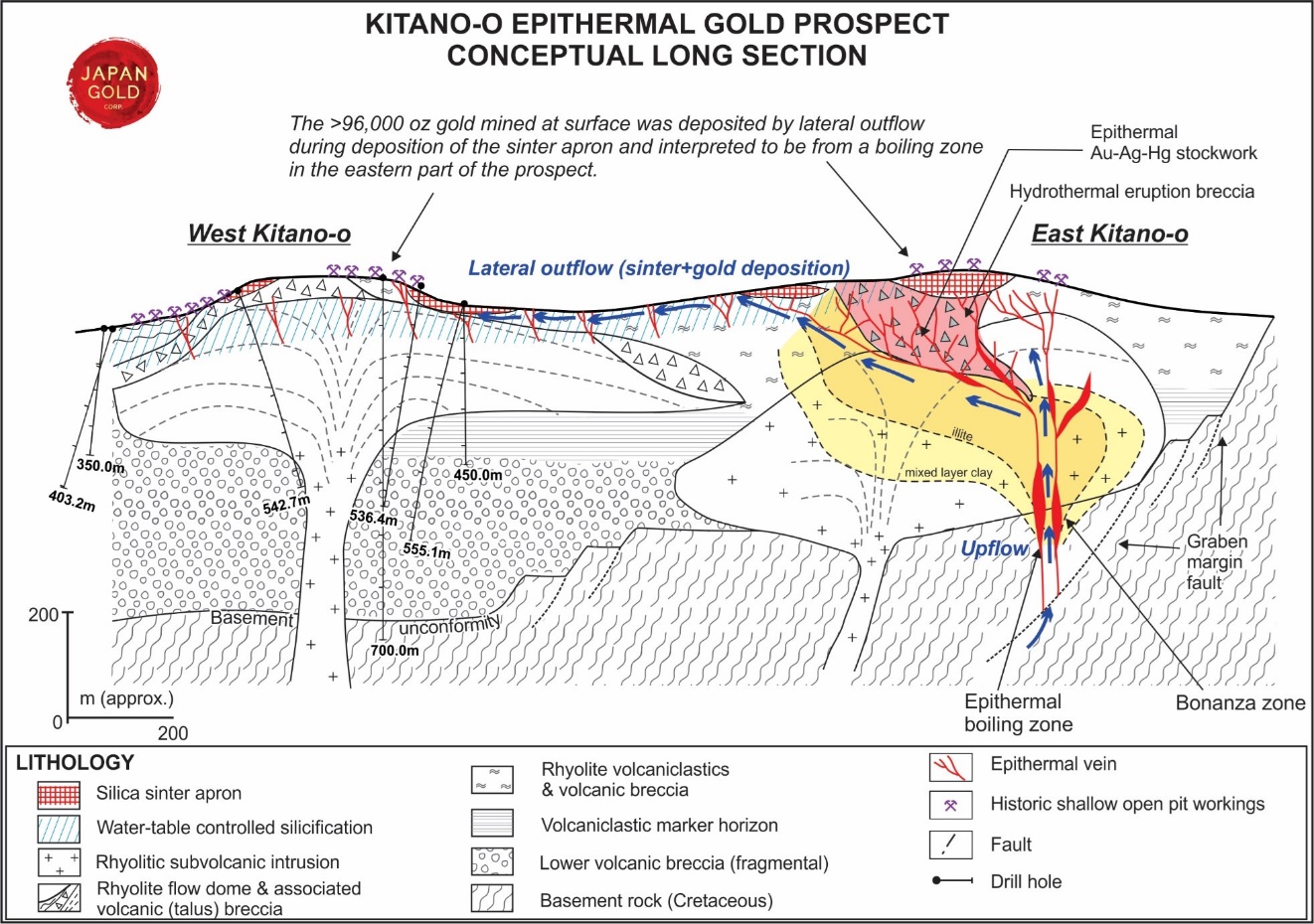 Conceptual model of the Kitano-o Gold Prospect.
Ryuo Prospect
The Ryuo mine was developed prior to 1943 on five vein zones. Underground workings of the Jinja and Shouei veins were mapped and re-sampled during the 1950’s, with the Metal Mining Agency of Japan (MMAJ) publishing these results in 19901. The compiled data shows workings developed on up to six levels to a depth of 75 m below surface, with veins reported up to 1.6 m wide. Incomplete production records indicate more than 5,000 ounces of gold were produced between 1938 and 1953, with grades averaging 8.9 g/t gold and 36 g/t silver4.
The Shouei vein was reportedly mined over a 200m strike length to a depth of 90m, and averaged a metre-wide, with average grades of 5.21 g/t gold and 132 g/t silver. The Jinja vein workings measured 120m long x 70m deep, with an average vein width of 1m, and average grades of 13.99 g/t gold and 110 g/t silver4. High-grade gold-silver quartz veins were mapped on all four of the lower levels of the Jinja vein system. Chip-channel samples collected at intervals spaced between 0.3 m and 4.7 m along the strike of the vein indicates significant high-grade shoots on levels 4, 5 and 6. (refer to the Company’s website news release dated February the 9, 2017.
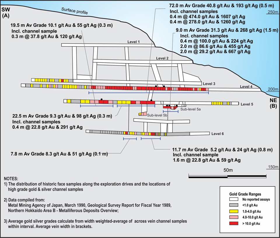 Ryuo Mine, Jinja vein workings. Long section of underground development showing highlights of historic channel sampling4
Japan Gold 2017-2019 work program
Japan Gold mapping at Ryuo has identified a 1,000 m by 400 m zoned alteration system comprising clay alteration enclosing a NE-SW oriented zone of silicified rhyolitic volcaniclastic rocks hosting gold-silver bearing quartz veins and hydrothermal breccias, the alteration system remains open to the southwest. Published data including underground channel sampling confirm the presence of high-grade mineralisation along significant vein lengths and highlights the potential for discovery of more high-grade epithermal gold/silver mineralization at the Ryuo mine. No drilling or modern exploration has been undertaken in the area, and Japan Gold plans to drill several targets at Ryuo in 2020.
A number of short phases of geologic mapping and prospecting took place over the main prospect area in 2018 and 2019, culminating in a ground CSAMT resistivity survey in November 2019 (six 200m spaced lines totaling 8.0-line km). This was supported by 100m spaced gravity stations collected over the broader Ryuo prospect area.
Akebono Prospect:
The Akebono prospect is located in the northeast corner of the Company’s Ikutahara Project within the granted Prospecting Rights licenced area. A drilling permit was granted in 2017 and the Company's first scout drilling program was completed at the Akebono prospect in December 2017. Initial drilling results confirm the presence of a high-grade gold event within the Akebono vein system previously indicated by historic sampling of underground workings.
Discovered in 1931, underground exploration at Akebono was carried out between 1938 and 1940, however, no production records were reported prior to government imposed gold mine closures in 1943. In the 1960’s the underground workings were re-entered and sampled along two drifts. The known workings consist of two 120 m long drives and several winzes sunk to a vertical depth of approximately 100 m. These were developed on a moderate to steeply dipping, 0.5 to 4 m wide epithermal gold-silver bearing quartz vein. Several high-grade samples were reported, including 1.2 metres @ 446 g/t gold and 376 g/t silver and 0.65 metres @ 91.5 g/t gold and 4,891 g/t silver4.
The main Akebono vein trends ENE-WSW and Japan Gold’s prospect mapping has shown that along its strike, banded and bladed textured quartz-chalcedony veins up to 4 m wide crop out over a 600m long NE-SW trend that is open in both directions along trend. Rock samples collected by the Company have returned encouraging gold and silver results up to 20.7 g/t Au and 290 g/t Ag from vein float.
The high historical gold and silver grades reported, and vein widths mapped up to 4 m, indicate the area around the Akebono workings, which has had no modern-day exploration, has great potential for further high-grade discoveries.
Recent surface mapping and prospecting in 2019 shows that epithermal vein mineralization likely extends southwestward along strike to Toge Ridge-upper Sakinzawa-Kitano-o.
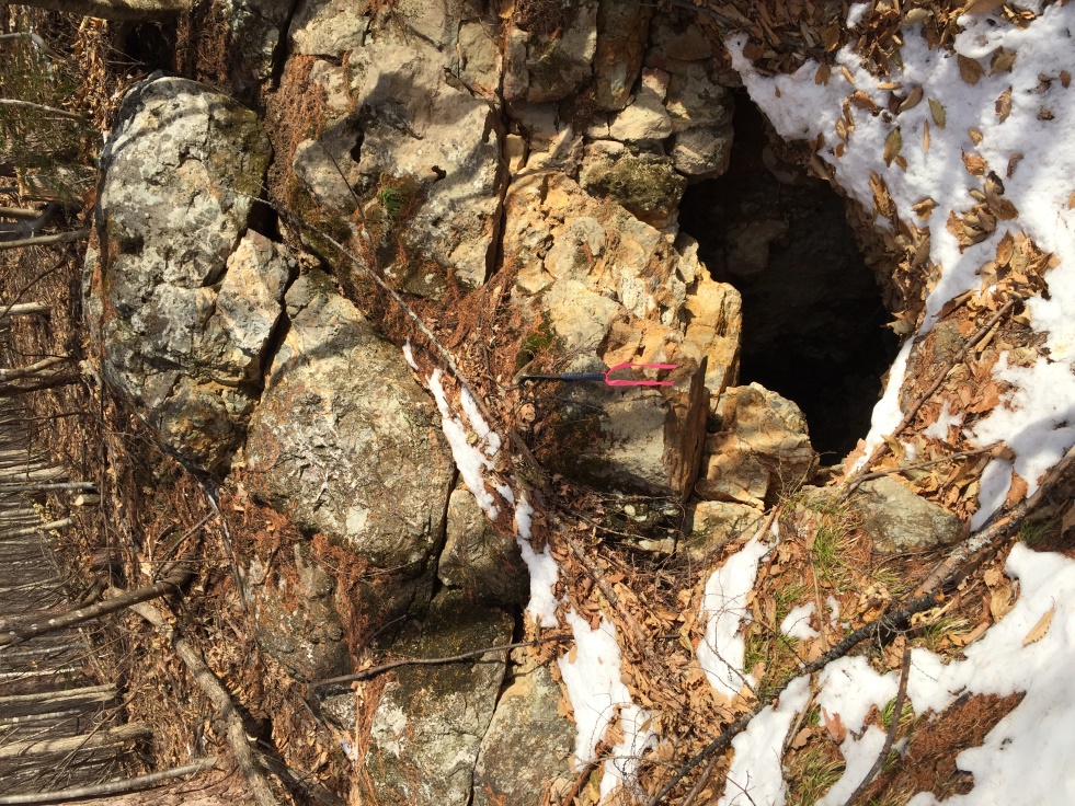 Top plate: Entrance to the collapsed upper drift (drive) along the Akebono vein
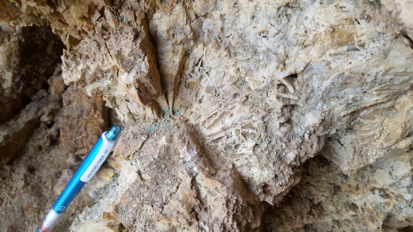 Bottom plate: Bladed quartz vein texture Akebono vein
Kitano-o North Prospects:
As a follow-up to April-November 2017 regional work of defined historic mine workings and associated drainage geochemical anomalies both semi-detailed & detailed geologic mapping and rock geochemical sampling of historical mine workings, together with traverses of streams, access roads and ridge lines were completed in April-May and October-November 2018 in initially the Sakinzawa-Maruyama areas. Additional historical workings were defined at Toge Hill and Asada Ridge areas.
Sakinzawa Workings: Three outcrop samples of quartz stockworked rhyolite in the Sakinzawa creek returned gold results ranging from 1.34 to 17.2 g/t Au , supporting a reconnaissance outcrop sample of 43.8 g/t collected in 2013. Corresponding silver results are generally low and range from 2.56 to 15.85 g/t Ag.
 Gold-bearing quartz stockwork (bottom image) from altered rhyolitic volcanic breccia outcrop (top image); SAM02069: 17.2 g/t Au, 15.85 g/t Ag, 452 ppm As, 20 ppm Sb
Ridge and spur soil sampling over both private and designated protected national forestry areas was undertaken in the area of interest in May and September 2019. for a total of 1,576 samples. Overall soil geochemistry is of low tenor, possibly reflecting a subtle style of LS epithermal quartz vein mineralization present in the district. Coincidental soil element geochemistry (Au±Ag±As±Ba± Sb±Se±Mo±Mn±Tl±W) anomalies seems attributable to quartz vein mineralization developed along the rhyolite-volcaniclastic contact and/or within the margins of the rhyolite. Often historical surface mine/prospect workings also define these areas. Other soil anomalies maybe attributable to vein mineralization developed (i) as Hishikari-style equivalents or (ii) favourable tensional / dilatational mineralizing structures developed within brittle lithological units as secondary features to district/subdistrict scale strike-slip faults.
ASD alteration mapping by Plus Minerals over the general area of interest concluded:
- That ammonium minerals, and in particular ammonium feldspar (buddingtonite), is likely to define quartz-adularia alteration, and map the upflow and boiling of epithermal fluids. This seems to be substantiated at Kitano West, where the main occurrence of sinter is found, and underlying epithermal quartz veins have been exploited by early miners. Based on this criterion, Kitano West is the most important exploration target in the map area, and the Sakinzawa prospect may rank second.
- Our preliminary impression is that Toge and Asada are singular veins, and do not comprise a wide vein array that could form a larger vein at depth (Buchanan model). Conversely the most likely place where multiple small sub-parallel veins could form a large vein at depth is Kitano
- Major structural control is needed to from large vein systems, but as shown by the Konami mine area, approximately E-W oriented veins are a feature of the Monbetsu-Rubeshibe belt, and may have widths of 20 m. However the largest faults are likely to be N-trending, and for the map area, they are in the Ikutahara valley. Quartz veins on major N-trending faults are likely to be more common than currently known, but these structures (and associated veins, if present) are concealed by Quaternary cover. They have exploration potential for a new discovery in Northern Hokkaido.
In October-November 2019, 200 by 100m gravity stations were collected over the Toge-Asada-Sakinzawa prospect areas. Gravity gradient enhancement / edge detection images by Fathom Geophysics appear to define some of the known structural trends well, i.e. the location of the basement unconformity, major NE, ENE and NW trending structures. It should be noted, or kept in mind, that some, or possibly most of the larger anomalies present on the Fathom imagery set, likely represent major or mid-sized regional- or district-scale structures which have seen significant strike-slip or dip-slip movement along them. These structures do not necessarily represent the mineralised ‘tensional’ structures, but importantly, movement along them, facilitated dilation in smaller subsidiary structures next to them.
Saroma-Chitose-Taiho Prospects:
The historic Saroma, Taiho and Chitose gold workings are developed on epithermal veins and sheeted vein systems located along an incised NE trending valley about 2-km SE of the Kitano-o District. The veins occur within an en echelon, left-stepping fault system that extends over at least a 4-km strike-length3. The host fault system defines the course of the large Saroma River and the rivers bedload features abundant epithermal quartz-chalcedony-adularia vein boulders.
History
Operated during the 1930’s, records show the Saroma mine produced 13,189 tons of ore at an average grade of 9.7 g/t gold between 1933 to 19394. There are no production records from Taiho and Chitose, however, there is an inference from historic records that exploration and mining commenced in these latter two areas immediately prior to the time of gold mine closures in 19431.
Japan Gold 2017-2019 work program
Geological mapping conducted by SAMJ early in 2017 located the historical workings in the Saroma and Taiho Prospect areas and confirmed the steeply dipping veins exposed there, strike ENE-WSW to NE-SW, and at Chistose, E-W. Veins show well developed colloform-crustiform banding, cockade crustiform and locally lattice bladed quartz textures, hosted by intercalated Mesozoic basement sandstone and mudstone. Some of the veins are emplaced along the contacts of rhyolite porphyry dykes.
The Saroma prospect hosts at least three sub-parallel vein sets traceable along a 1.2-kilometer, open-ended strike zone. Vein thickness varies from a few centimeters to approximately 5.0 meters, as observed in the historical workings.
 Saroma prospect; white colloform-crustiform chalcedony-quartz-adularia veins and locally complex quartz-breccia veins and bladed carbonate replacement textures
An open historic mine drive identified at Taiho during 2017 is accessible via a short portal located beside the main Taiho creek. The structure, named the Honrhyu No. 1 Vein, trends ENE-WSW, dips 70-75° NW, and is described by the MMAJ as being up to 7-m wide and having a 1.5-kilometer strike-length4. The Honrhyu Vein appears to pinch and swell (<1-2.5-m wide) along a 25-m underground section of the drive and is open at both ends of this working. A series of steeply dipping WNW-ESE trending sheeted quartz veins and breccias were mapped on the eastern edge of the drive, and these seem to splay (‘horse-tail’) off the main vein structure near the second portal entrance on the river. The Honrhyu Vein can be traced at surface about 450 meters along a ENE to NE strike with a widest mapped vein thickness of 1.60 meters. The Company’s prospecting work is yet to cover the Chitose Prospect area in detail.
Six of nineteen samples taken at Saroma returned gold and silver results ranging from 2.21 to 10.85 g/t Au and 17.9 to 136 g/t Ag, respectively. These samples are from angular boulders and outcrops of milky white colloform-crustiform chalcedony-quartz-adularia(?) veins and locally complex quartz-breccia veins and bladed carbonate replacement textures. The fine-grained nature of quartz combined with vein textures evident at Saroma and Taiho indicate textures typical of boiling zone and gold precipitation in epithermal systems.
Ikutahara Project: Saroma Prospect Significant Rock Chip Results (>1 g/t Au)
|
Prospect |
Sample No. |
Sample Type |
Au g/t |
Ag g/t |
Hg ppm |
As ppm |
Sb ppm |
Se ppm |
Te ppm |
Tl ppm |
Cu ppm |
Pb ppm |
Zn ppm |
Mo ppm |
|
Saroma |
SAM01824 |
Float |
10.85 |
127 |
0.09 |
17.9 |
27.4 |
7 |
0.1 |
1.25 |
8.6 |
60 |
2 |
8.27 |
|
Saroma |
SAM01832 |
Float |
4.67 |
136 |
0.07 |
15.8 |
53.2 |
5 |
0.44 |
0.37 |
6.3 |
7.4 |
2 |
5.65 |
|
Saroma |
SAM01828 |
Float |
2.72 |
45 |
0.11 |
18.5 |
46.1 |
1 |
0.07 |
0.012 |
5.5 |
2.8 |
<2 |
5.82 |
|
Saroma |
SAM01830 |
Float |
2.21 |
41 |
0.09 |
22.9 |
45.8 |
1 |
0.06 |
0.71 |
7.6 |
4.2 |
3 |
5.69 |
|
Saroma |
SAM01827 |
Float |
1.97 |
129 |
0.1 |
22.2 |
48.9 |
3 |
0.35 |
1.17 |
8.1 |
7.3 |
3 |
8.31 |
|
Saroma |
SAM01829 |
Float |
1.08 |
17.9 |
0.15 |
165.5 |
43.1 |
2 |
0.35 |
2.3 |
8 |
3.8 |
3 |
14.85 |
|
Saroma |
SAM01835 |
Outcrop |
1.01 |
52 |
0.11 |
52.8 |
40.3 |
2 |
<0.05 |
2.01 |
24.9 |
12.2 |
8 |
9.28 |
The vein systems mapped at Saroma and Taiho are sufficiently large to host multiple ore shoots if the hydrothermal processes conducive to high-grade gold deposition were active during their formation. A follow-up exploration program for these prospects is planned.
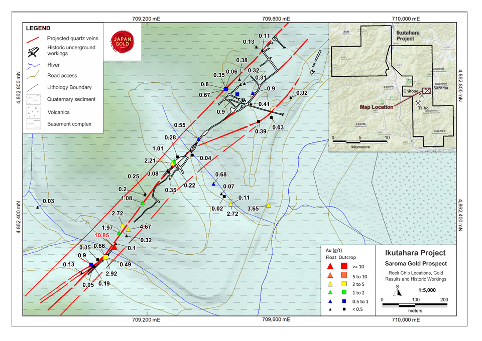 Saroma Prospect, Significant Gold Results from Surface Rock Sampling
References
1 Watanabe, Y (1996). Genesis of Vein-hosting Fractures in the Kitami Region, Hokkaido, Japan, Resource Geology, 46(3), pp 151-166.
2 Gold Mines in Japan, The Mining & Materials Processing Institute of Japan, 1990.
3 Watanabe, M (1940). Showa – Kitano-o type gold deposits, J. Japan, Assoc. Min. Petr. Econ. Geol. 23: pp. 28-39 (in Japanese).
4 Metal Mining Agency of Japan, March 1990, Geological Survey Report for Fiscal Year 1989, Northern Hokkaido Area B - Metalliferous Deposits Overview.
5 Garwin, S., et al. 2005. Tectonic Setting, Geology, and Gold and Copper Mineralisation in the Cenozoic Magmatic Arcs of Southeast Asia and the West Pacific, Appendix 1, Economic Geology 100th Anniversary Volume, p 891-930.
6 Maeda (1990) Mineralization Ages of Some Epithermal Gold-Silver Vein-type Deposits in the Central Kitami Mining District, Hokkaido, Japan.
7 Bamba & Saito (1956) Gold-silver deposits of Kitano-o and Several Other Mines, Ikutahara Gold Mining District, Kitami Province, Hokkaido.
8 Austpac Gold NL company reports 1992-1993.
9 Sillitoe et. Al. (2015) Epithermal paleosurfaces. Mineralium Deposita (2015) 50:767-793.
10 Maeda, H. (1996). Relationship between volcanic activity and epithermal gold-silver mineralization: Example from Kitano-oh mine area and vicinity in Kitami metallogenic province, Hokkaido, Japan, Resource Geology 46 (5): pp. 279-285.