Togi Project
Overview
| Commodity: | Gold |
| Target: | Low Sulphidation Epithermal Gold |
| Location: | Noto Peninsula, Honshu Island |
| Size: | 3,990 hectares |
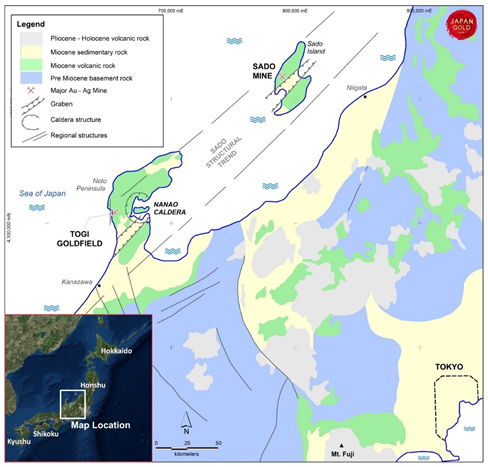
Geological setting of the Togi Project, Noto Peninsula, Honshu Island, Japan
Togi Project
Japan Gold's new Togi Project is located on the northern flank of a regional graben, hosted in early Miocene andesite volcanics and under-lain by a northeast trending gravity anomaly. A similarly oriented graben-gravity feature and Miocene host rocks are noted 160 kilometres along strike to the northeast on Sado Island, which hosted Japan's second largest gold mine, the Sado Mine which produced 2.5 million ounces of gold and 74 million ounces of silver2 until its closure in 1974. The Company believes the area is underexplored and highly prospective for epithermal vein discoveries, akin to the Sado Mine.
Togi Goldfield
Gold mineralisation was discovered in the Togi area in 1896 and historic records from the Togi Goldfield report seven separate areas of workings along the seven-kilometre trend which produced a combined 48,000 oz of gold and 180,000 oz of silver between 1910-21. Deposits mined in the project area are divided into the Hirochi deposits in the northeast and Urugami deposits in the southwest. The Mori vein from within the Hirochi group produced 16,500 oz of gold at an average grade of 14 g/t. The vein is reported to be up to four metres wide, with gold values ranging between 8 and 20 g/t gold1. Records show the mineralisation at lower mine levels open at depth with average grades of 8.12 g/t gold and 56.9 g/t silver1, workings did not exceed 120 metres below portal level.
In the southwest area of the Togi Goldfield, historic mine workings on the Urugami deposits cover over 30 small veins and stockwork zones within a two by two kilometre zone. The Togo Mine, the largest within the Urugami area, produced over 18,000 oz of gold and 83,000 oz of silver from stockwork vein and breccia zones1,3. Sinter mapped at Urugami and the narrower stock-work style of quartz vein mineralisation indicate the top of a hot-spring epithermal system is preserved, thus supporting the potential for deeper boiling-zone vein targets.
Historic exploration and drilling results
In 1988 the NICAM joint-venture between the Nissho-Iwai Corporation and Austpac Gold NL undertook exploration in the Togi Goldfield. Work completed included mapping, rock and soil sampling, and CSAMT surveys and included four diamond drill holes in 1990. A summary of this work is included in Figure 2 with gold in rock values, alteration mapping and the 1990 drill hole locations and intercepts. Drilling intercepted anomalous gold values including an 11.3 metre interval of silicification and brecciation averaging 0.45 g/t gold, including 1.85m @ 2.72 g/t gold from 335.6 meters downhole3. The four reported drill holes are anomalous and encouraging but have insufficiently tested the seven-kilometre corridor.
Areas of intense clay alteration seen along road cuts between the Hirochi and Urugami deposits suggest continuity of the hydrothermal system between the two main deposit groups, and along the seven kilometre structural trend3, further emphasizing exploration potential. Additional reconnaissance work is planned at Togi for 2019.
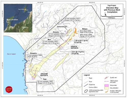
Togi Goldfield Project showing clay alteration zones, historic workings and NICAM JV compilation.
References
1 Gold Mines of Japan, 1989. The Mining & Materials Processing Institute of Japan
2 Garwin et al. 2005. Tectonic setting, Geology, and gold and copper mineralization in the Cenozoic magmatic arcs of Southeast Asia and the West Pacific. Economic Geology 100th Anniversary Vol. pp 891-930
3 Austpac Gold NL., 1988-94. Company Annual Reports