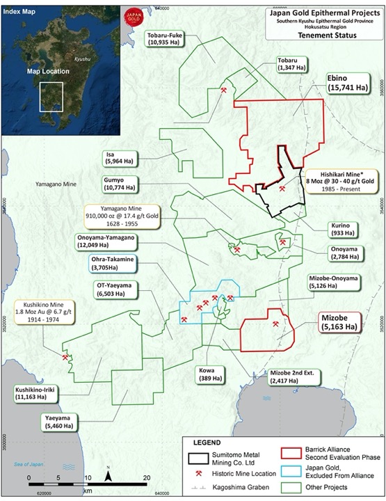
The Ohra-Takamine Project
Overview
| Commodity: | Gold-Silver |
| Target: | Low Sulphidation Epithermal Gold |
| Location: | Southern Kyushu, Japan |
| Size: | 3,705 hectares |
3D Model Deck
Highlights
- The Ohra-Takamine project lies within the Hokusatsu-Kushikino mining district, 7.5 kilometres to the southwest of the historic Yamagano mine which produced 910,000 ounces of gold at a grade of 17.4 g/t. Within the property historical production included the Ohra (27K oz gold), Takamine-Urushi (13K oz gold) and Takamine (1.6K oz gold) mines. Vein number 2 of the Takamine-Urushi mine was reported to carry gold grades between 50-100 g/t1,2.
- Other notable gold producers within the district include: Hishikari mine with 7.6 million ounces produced to date at average grades of 30-40 g/t7; Kushikino mine, 1.8 million ounces at 6.7 g/t; Yamagano mine, 910,000 ounces at 17.4 g/t; and the Ohkuchi mine with 714,000 ounces at 13.6 g/t4,8.
- The presence of sinter at several localities indicates the fossil geothermal system is well preserved and with known surface/near surface mineralization, represents a significant exploration target for shallow-level epithermal gold-silver deposits.
- Like all of the major gold mines in the Hokusatsu-Kushikino mining district, the Ohra-Takamine project straddles the margin of a gravity-high feature inferred to indicate upward doming of the basement which produced suitable fracture pathways for mineralised hydrothermal fluid flow.
Project Details
The Takamine-Urushi Project comprises eleven (11) contiguous Prospecting Rights blocks (3,705 Ha) near the coastal town of Kirishima in southern Kuyshu. The project area contains an intact mineralized low- sulfidation epithermal vein system part of which was mined up to 1943. Regional metallogenic surveys and later prospect evaluation work (including some scout diamond drilling) by the Metal Mining Agency of Japan (‘MMAJ’) in the 1980’s has further enhanced the level of geological understanding on this property.
History
Initially discovered in 1885 and mined periodically to 1943 the Ohra mine produced in the order of 27,000 ounces of gold at grades reported between 3.5 to 20 g/t. The northeast striking vein is reported as 1,200m long with an average width of 0.9 meter1,2.
The Takamine and Takamine-Urushi mines were discovered in latter part of the nineteenth century and mined periodically up to 1943. Takamine mine produced 9,654 tonnes of ore with average grades of 5.1g/t gold and 28.3 g/t silver. The vein strikes northeast, has a length of 450 meters, and average width of 1 meter.
Takamine-Urushi mine was estimated to have produced 13,000 ounces of gold between 1896 and 1916. Three northeast striking gold-bearing quartz veins, with lengths up to 350m were mined, the so-called number 2 vein was reported to carry gold grades between 50 to 100 g/t1,2.
The Metal Mining Agency of Japan (MMAJ) (Metal Mining Agency of Japan) conducted regional and more detailed studies over the Ohra-Takamine area between 1982 and 1989, eight drill holes were completed as part of this work. Drill hole 60MAH-2 located to the east of the Takamine-Urushi mine intersected two 10-centimetre wide quartz veins with respective gold grades of 12.3 and 13.3 g/t, 100 meters below the deepest mine workings, and approximately 245 meters vertically below surface3.
Four other historic Au mines (Yamada, Kohwa, Kizushi and Maruyama) are reported from outside the application area, located 1 to 3 km to the east and south-east.
Yamada mine was mined by Kagoshima Mining Co. from 1916 to 1930 after which the mining rights were transferred to local people. 7000t of ore was produced with average grades of 4 to 5 g/t Au (~1000 ounces). Kohwa mine was operated from 1946 to 1963 by Takara Mining Co. Kizushi mine was operated by local people from 1910 to 1926. Maruyama mine (also known as Oh-shika mine) was opened in 1925 and operated until 1928 with approximately 100 kg (14,100 ounces) of gold produced (METI, 19893).
More recent MMAJ exploration undertaken between 1979 and 1993 as part of a regional metallogenic study included regional geophysical surveys and prospect-scale surface sampling and drilling.
- 1979: Regional gravity survey completed which concluded that known gold deposits were associated with gravity high anomalies.
- 1982: Geochemical survey undertaken with 415 soil samples and 145 rock chip samples collected. One hundred and five (105) of the samples were analysed via X-ray diffraction to determine alteration mineral type.
- 1985-1989: Eight drill holes were completed within the property area (59MAHT-2,3; 60MAHT-2; 61MAHT-2,3,4,5; and 63MAHT-5). Drill hole 61MAH-2 located to the east of the Takamine-Urushi mine intersected two 10-centimetre wide quartz veins which assayed 12.3 g/t Au and 13.3 g/t Au respectively. These intercepts were 100 meters below the deepest mine workings, and approximately 245 meters vertically below surface.
- 1991: Two drillholes (63MAHT -1/2, drilled to 300.1m and 400m respectively) tested a resistivity anomaly along strike and down dip of the Yamada mine. Intercepts of 0.6m @ 0.18 g/t Au from 203m (3MAHT – 1) and 0.6m @ 0.14 g/t Au from 227.35m (3MAHT – 2) were returned.
- 1992: Geochemical rock chip sampling was undertaken to the east of the property with samples also analysed for alteration minerals.
- 1993: Sixty-four quartz vein and sinter samples were taken from around the Aira mines (Maruyama, Kizushi, Kowa) with six samples returning assays >10 g/t Au (mostly proximal to Maruyama) to a maximum of 154 g/t Au. Based on these high grades a drillhole (65MAHT-1, depth 502.4m) targeted along trend to the north-east of Maruyama mine and was mostly unmineralized with a single interval reporting an intercept of 0.15m @ 0.17 g/t Au from 324.5m.
Geology and Mineralisation
Geology of the Ohra-Takamine Property comprises a sequence of predominately Pleistocene aged volcanics underlain by Pliocene sediments and volcanic rocks (Kagoshima Block, 1997).
The Hokusatsu andesite is the primary host rock to known gold deposits, reported to be Middle Pleistocene in age (1.8 Ma 4Watanabe, 2005). The formation comprises andesitic to dacitic intrusives and volcanics of the same composition.
Small areas younger post-mineralisation Ito Formation volcanics cover the other units in the southeast of the project.
The seven Au mine deposits found within and in proximity to the Ohra-Takamine property are classified as rift low-sulphidation epithermal. Details of the mineralization at the deposits are described below.
The Takamine-Urushi mine was developed over three northeast (N45° E) striking gold-bearing quartz veins, with lengths up to 350m. The No. 2 vein was reported to carry gold grades between 50 to 100 g/t. Quartz-calcite-adularia veins were notable for massive zones consisting of black bands and transparent quartz. Native gold, pyrite, chalcopyrite and sphalerite are recorded. Fluid inclusions temperatures of 213 to 227 degrees have been reported (6METI, 2000).
Takamine mine vein strikes northeast, has a length of 450 meters, average width of 1 metre and was exploited over a vertical height of 120m (METI, 1989). Veins are composed of quartz with lesser amounts of calcite, carrying native-gold, pyrite, galena and manganese-bearing minerals. Fluid inclusion temperatures of 233 to 252 degrees are recorded (6METI, 2000).
The Ohra northeast striking vein is reported as 1,200m long with an average width of 0.9 meter (1Michitoshi, 1967). Three veins are recorded striking N60°E dipping 60°N. Average widths of the quartz-calcite veins are 0.9m. Veins are divided into many small parallel veinlets carrying native gold, argentite, chalcopyrite, pyrite and galena. A fluid inclusion temperature of 221 degrees is recorded (6METI, 2000).
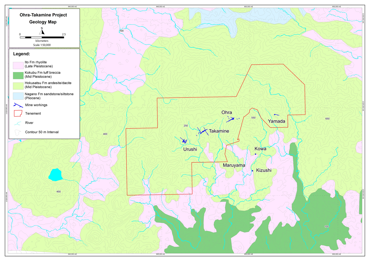 Historical mine localities and geology of the Ohra-Takamine property
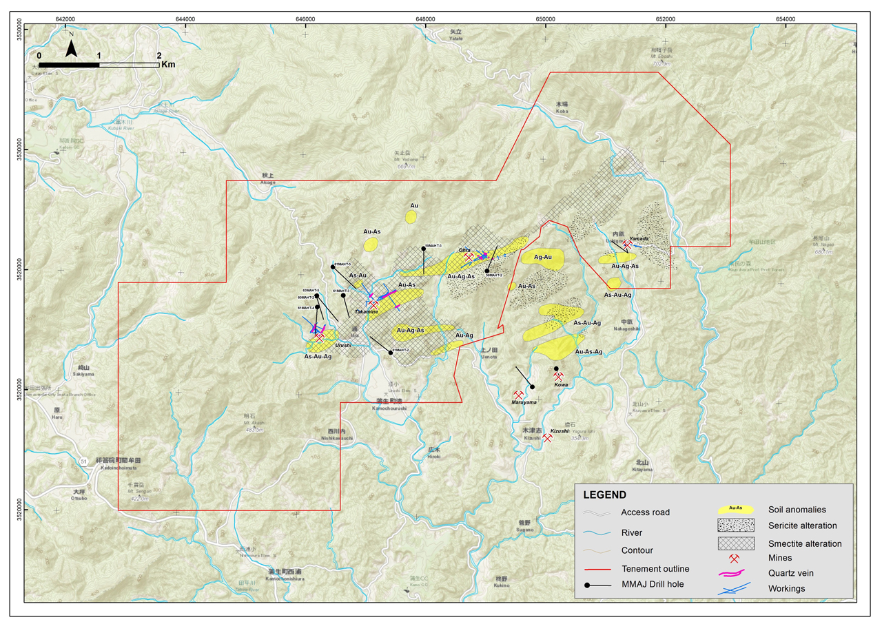 Ohra-Takamine mine workings, drillhole locations, soil anomalies and hydrothermal alteration zones
Exploration
The Company to date has conducted literature reviews and data compilation along with its own geological mapping and sampling campaigns. Recent prospect evaluation work in Q1 2020 has comprised:
- Grid-based B/C horizon soil sampling over a4 km long, and 3.3 km wide sample grid covering the Ohra-Takamine-Urushi area. Composite soil samples were collected at 50 m spacings along 33 individual, north-south orientated grid lines, located 200 m apart. Multi-element geochemical assay and clay spectral analysis were completed on both composite soil samples and accompanying rock-chip samples. Geological and alteration mapping completed in parallel with the soil sampling program has also been compiled and merged with the data set. Soil results confirm the presence of gold and silver in soil anomalism (5 defined areas) across and around the known historical Ohra, Takamine and Urushi mine workings. Anomalous gold in soil along the mine corridor correlates well with elevated levels of the important pathfinder elements, antimony and arsenic. Collectively, gold, silver, mercury, antimony and arsenic provide excellent vectors to lesser explored and understood, high-level alteration zones present to the north and south, and along strike, of the mine corridor. Overall spectral alteration mapping shows a smectite-clay halo following the vein/mineralization trend, and also mutually supports soil anomalism northeast of Ohra and to the north-northwest of Takamine. To the southwest of Urushi younger cover rocks prevail, but continuity of alteration is also apparent.
- A 35 line-kilometer, grid-based, CSAMT geophysical survey was completed along a 4.2 kilometer portion of the Ohra-Takamine Mine corridor. The CSAMT geophysical survey was undertaken to identify zones of sub-surface electrical resistivity and conductivity, representing silicification and clay alteration related to epithermal vein systems. Results of the CSAMT survey are encouraging having defined a number of linear kilometric-scale, contiguous resistive zones (CSAMT anomalies), locally extending to depth across the survey area.
- Bouguer gravity data collected by Haines Surveys Pty Ltd, over an approximate 8 by 4 km area, was merged with regional Geological Survey of Japan gravity data. Fathom Geophysics re-processed the merged data set to enhance rapid changes in gravity gradient. The resulting imagery aids in detection of under-cover or deep-seated basement structures not obvious at surface, along with some definition of structural architecture and faulting which allows pathways for hydrothermal fluid flow, and subsequent quartz vein formation. The spatial relationship between gravity highs and the major low-sulphidation epithermal gold deposits in the province is well described in the literature, and uplift or doming of the underlying basement, producing gravity anomalies, is interpreted as a key factor in the development of deep-seated fracture pathways for hydrothermal fluid flow, and subsequent quartz vein development in these mines.
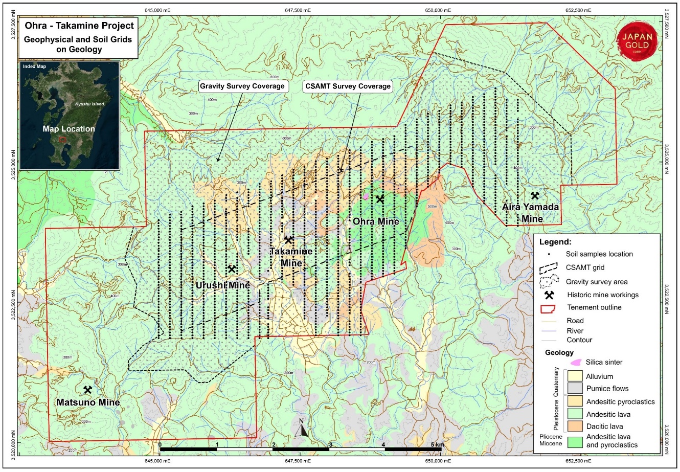 Ohra-Takamine Gold Project, Soil grid, CSAMT and gravity geophysical survey locations on geology.
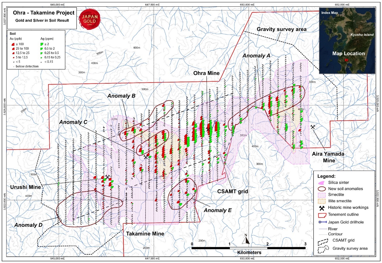 Ohra-Takamine Gold Project, Gold & Silver in soil anomalies with alteration and Structure-Geochem coincident anomalies
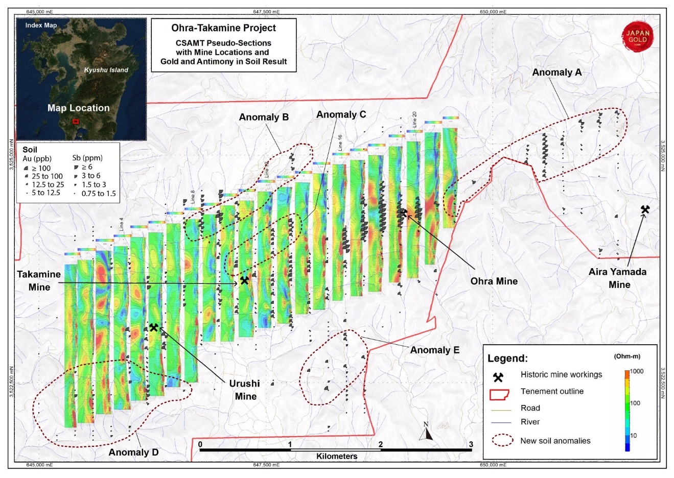 Ohra-Takamine Gold Project, CSAMT stacked pseudo-sections with mine locations and gold / antimony soil anomalies.
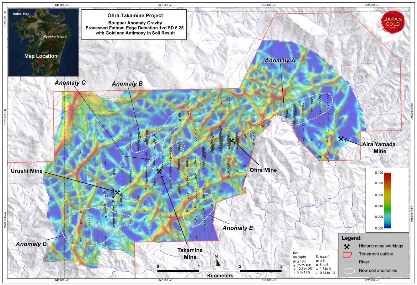 Ohra-Takamine Gold Project, processed gravity with edge detection for structure definition and gold / antimony soil anomalies. Red lines on the gravity image represent contoured gravity gradients and define linear features interpreted to represent basement off-sets and major structures
Phase 1 Drill Program
Only one single (OTD001) and one incomplete (OTD002) Phase 1 scout drillholes totaling 489.3m were completed in Q3 2019, before a management decision was taken to suspend drill operations and move drill crews to Ikutahara in order to complete the 2019 Kitano-o drill campaign before the onset of winter conditions.
Coincident northeast trending gold soil anomalies with other pathfinder elements have been identified overlying contiguous linear zones of high CSAMT resistivity at the Ohra-Takamine Project. Japan Gold is targeting its forthcoming drilling program based on integration of these geochemical, geophysical and geological datasets. Drilling will target defined extensions and parallel vein shoots below and along strike of shallowly developed mine workings and also further along the alteration corridor.
Ohra-Takamine Central Mine Corridor Scout Drill Program
Three scout holes were drilled (total 1624.0 metres (m)) along the central 3.5 kilometres (km) corridor of alteration and epithermal-gold mineralization defined by the Ohra, Takamine and Urushi historic mines. Drilling encountered narrow high-grade gold vein intercepts below the Urushi Mine, and multiple gold-anomalous sheeted quartz vein zones below the Ohra Mine workings (see March 16, 2021 news release for more information).
Information gained from these scout drill holes has been assessed along with coincident anomalies of CSAMT, soil geochemistry, alteration and geological mapping. These results have defined a series of un-tested targets that lie both along strike of, and parallel to the historic mines. The combined strike length of these more coherent geophysical-geochemical-alteration anomalies represents a series of priority drill target areas with a cumulative strike length of over 5 km. A separate, coincident soil geochemical - alteration anomaly extends the Ohra alteration system another 2.5 km along strike to the northeast. Geophysical surveys are planned to further define this large anomaly.
The discovery of new vein zones with limited or weak surface outcrop in the vicinity of the Urushi Mine as well as between the Ohra and Takamine Mines, gives encouragement for the exploration potential both along the trend and below cover further along strike to the southwest, where coincident soil and CSAMT anomalies are partly concealed by younger post-mineral geology.
Exploration Potential
The Ohra-Takamine project is located within the highly gold endowed Hokusatsu-Kushikino mining district, in the northern part of the Southern Kyushu Epithermal Gold Province. In excess of 10 million ounces of gold has been produced from high grade epithermal deposits of the district. Notable gold producers within the district include: the Hishikari mine with 7.6 million ounces produced to date at average grades of 30-40 g/t7; Kushikino mine, 1.8 million ounces at 6.7 g/t; Yamagano mine, 910,000 ounces at 17.4 g/t; and the Ohkuchi mine with 714,000 ounces at 13.6 g/t4,8.
Due to the high prospectivity of the district, known auriferous low sulfidation epithermal vein mineralization both within and peripheral to the property and basically intact fossil geothermal systems, the company believes this area is worthy of more detailed exploration. Based on recent prospect evaluation success with the definition of inferred new target zones and extensions to known veins along the Ohra-Takamine-Urushi mine corridor the Company feels scout drill testing of such targets is warranted.
References
1 Michitoshi Miyahisa, 1967: Report of gold deposits survey in Takamine/Ohra district, Kagoshima prefecture, Association of Kagoshima Prefecture mineral resources development promotion.
2 Gold Mines of Japan, 1989. The Mining & Materials Processing Institute of Japan.
3 MITI (1984- 1989): Report on the regional survey of the Hokusatsu-Kushikino region, Showa 58 (FY) to 63(FY). Ministry of International Trade and Industry.
4 Watanabe, 2005. Late Cenozoic evolution of epithermal gold metallogenic provinces in Kyushu, Japan. Mineralium Deposita (2005) 40: pp 307-323.
5 Ota, R., Koriyama, S., and Wakimoto, Y., Geological classification of Shirasu, Planning Department of Kagoshima Prefecture, 1967. pp. 7-19 (in Japanese).
6 METI, 2000. Report on the regional geological structure survey in the Hokusatsu-Kushikino area in the fiscal year Heisei 11. The Agency of Natural Resources and Energy of MITI.
7Sumitomo Metal Mining Co., LTD. website.
8 Garwin et al. 2005. Tectonic setting, Geology, and gold and copper mineralization in the Cenozoic magmatic arcs of Southeast Asia and the West Pacific. Economic Geology 100th Anniversary Vol. pp 891-930