History
Recorded gold and silver production from the historic Numanoue mine (1923-59), located within the property, is 45,171 oz gold and 3.02 Moz silver2. Production was from a series of underground workings that total 22.5 km in length, mined to depths of < 150 m beneath surface (Table 1). The ore is described as fractured milky-white quartz that is surrounded by bladed quartz with varying degrees of silica replacement and recrystallization (‘bosa’ texture, indicative of boiling and quartz pseudomorphs after bladed calcite). Grades of 500 g/t Au and 3,000 g/t Ag are reported from local bonanza zones2 (raw analytical data upon which these results are based is not published, and thus, unavailable).
Table 1. Numanoue Lode Production Statistics3
|
Name of Vein |
Strike |
Dip |
Horizontal length (m) |
Vertical extent (m) |
Average width (m) |
Average Au (g/t) |
Average Ag (g/t) |
|
Matsu-Hi |
N75°E |
80°N |
400 |
150 |
1.5 |
8.0 |
150 |
|
Matsu-Ueban-Hi |
N65°E |
75°N |
150 |
60 |
0.5 |
17.0 |
1500 |
|
Matsu-Shitaban-Hi |
E-W |
70°S |
150 |
120 |
0.2 |
9.7 |
100 |
|
Take-Hi |
N80°W |
70°N |
370 |
100 |
1.0 |
14.3 |
130 |
|
Ume-Hi |
N80°W |
70°N |
220 |
50 |
0.5 |
2.7 |
15 |
|
Wakaba-Hi |
N60°W |
75°S |
200 |
90 |
0.6 |
7.1 |
510 |
|
San-Go-Hi |
N75°W |
70°N |
70 |
90 |
0.3 |
2.8 |
110 |
|
Yon-Go-Hi |
N65°W |
70°N |
140 |
120 |
0.5 |
9.0 |
850 |
|
Go-Go-Hi |
N65°W |
70°N |
200 |
130 |
0.4 |
9.0 |
1150 |
|
Roku-Go-Hi |
N65°W |
70°N |
300 |
120 |
1.0 |
9.3 |
420 |
|
Roku-Go-Mae-Hi |
N85°W |
70°S |
100 |
90 |
0.3 |
14.4 |
1410 |
|
Shimararagi-Hi |
E-W |
80°S |
200 |
60 |
4.5 |
5.5 |
40 |
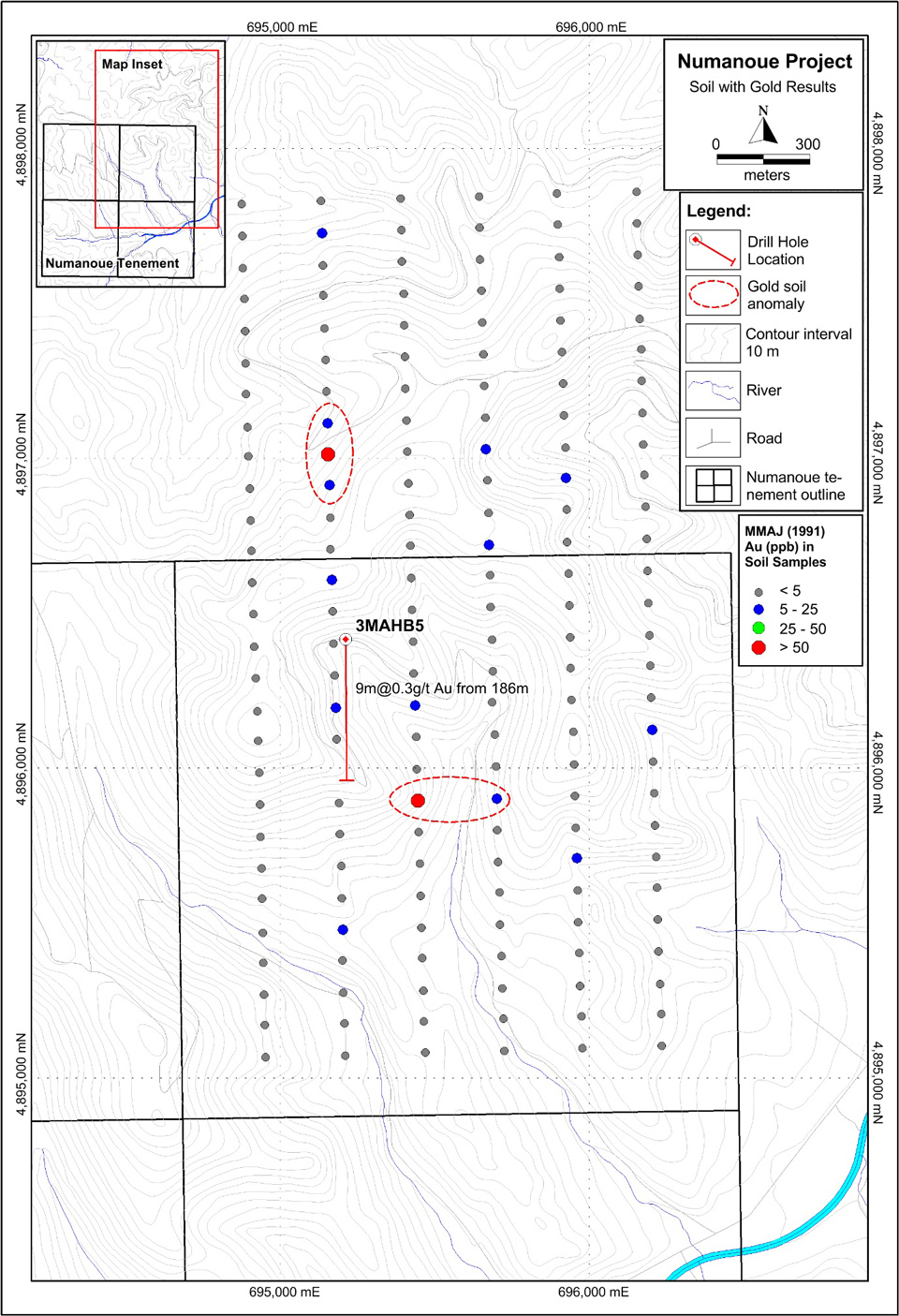
More recent exploration has been undertaken in the early 1990’s by the MMAJ as part of a regional metallogenic study which included an IP survey, soil and rock chip sampling and a single diamond drill-hole. In 1991, the MMAJ completed eleven lines of IP over the north-east portion of the project area. The lines ranged from 1.6 to 2.7 km in length and were spaced approximately 250m apart. Results of the IP survey revealed discrete resistivity and chargeability anomalies interpreted to represent zones of silicification and pyrite/clay alteration respectively. Most of the anomalies cluster within the northwestern part of the survey. The MMAJ considered that an overlap of high resistivity and chargeability represented the most likely location for mineralization and subsequently targeted such a zone with a diamond drill-hole that returned about 130 m of silicification and argillic alteration plus adularia from a depth of 170 m down-hole. Narrow quartz veins are reported between 170 and 195 m depth, including an intercept of 9.0 m at 0.3 g/t Au from 186 m downhole4 (information on the true width and frequency of this quartz veining is not published).
One hundred and sixty-seven soil samples were collected at a 50 m spacing along six discrete north-south trending IP lines, located 100 m apart, returning highlights of 98 ppb Au (average ~ 3 ppb, range 0.5 – 98 ppb), 3.07ppm Ag (average ~ 0.2 ppm, range 0.01 – 3.07 ppm) and 112 ppm As (average ~ 27 ppm, range 2 – 112 ppm)4. Two discrete gold anomalies and four coincident arsenic-antimony anomalies are apparent. Subsequent geological mapping was undertaken with fifty-nine rock chip samples of altered outcrop and float collected and assayed. The mapping revealed the presence of a northeasterly trending structure intruded in part by an andesite dike.