Vancouver, British Columbia--(Newsfile Corp. - February 22, 2023) - Japan Gold Corp. (TSXV: JG) (OTCQB: JGLDF) (the "Company") is pleased to announce results from 2022 work programs completed over the Kitano-o Gold District within the Ikutahara Project, northern Hokkaido. 2022 work programs included completion of an extensive soil geochemical survey covering 1,710 hectares and three scout drill holes on the east side of the Kitano-o prospect.
Highlights
- Analytical results from the recently completed soil survey have identified several significant gold anomalies with supporting pathfinder element and alteration signatures up to 1.5 km in length, which remain open ended.
- Clay alteration interpreted from spectral analysis along with geological mapping supports the soil generated anomalies and indicates full preservation of up to three epithermal systems across the district.
- Drilling to date has targeted depth extensions of gold-rich eluvial placer and sub-sinter veins but has not yielded a source for the significant amount of gold precipitated at the paleo-surface. It is now interpreted that these gold-rich paleo-surface expressions are de-coupled from boiling zones developed at depth.
- Gravity defined structures, CSAMT, geological mapping and drill core have provided a structural foundation supporting the new soil results and define new un-tested zones for further advancement to drill targeting.
"We are pleased with the results and conclusions from the extensive soil grid and additional drilling across the Kitano-o District. Critical gaps in the data set have now been filled and define three open-ended anomalous zones up to 1.5 km long that mimic the structural setting of the large Konomai veins located along the same graben to the northwest. We now have a clearer interpretation which is guiding the targeting of boiling zones that generated the gold-rich paleo-surface placers at Kitano-o and Ikutahara", commented John Proust, CEO of Japan Gold Corp.
Kitano-o Gold District soil survey program:
Three campaigns of soil sampling were completed over the Kitano-o Gold District between 2020 and 2022 covering a prospective 1,710 hectare area, (Figure 1). A total of 1,597 composite soil samples were collected along a 7 km long section of a major deep-seated graben fault which bounds the east side of the district. The district hosts numerous historical mines and workings, the most notable of which include the Kitano-o mine which produced more than 96,000 ounces of gold at an average grade of 5.9 g/t Au1, 2, and the Showa and the Ikutahara mines which produced 6,600 ounces of gold at an average grade of 16.8 g/t and, 16,200 ounces of gold at an average grade of 5.2 g/t gold, respectively1,2. These deposits host both hot-spring sinter-level, eluvial-placer mineralization, and shallowly developed sub-sinter banded chalcedonic quartz veins. The abundance of gold in these eluvial placer style deposits, particularly at Kitano-o is believed to represent surficial out-flow or leakage from a deeper boiling zone source. The presence of both sinter material at Kitano-o and of numerous areas of steam-heated clay alteration represent the preserved paleosurface and support an interpretation for at least three fully preserved epithermal systems developed at depth within the district.
Drilling to date has targeted depth extensions of surficial gold-rich eluvial-placer and sub-sinter veins which have not yielded a source for the significant amount of gold precipitated at the paleo-surface. With a more complete geochemical coverage, it is now interpreted that these gold-bearing paleo-surface expressions are de-coupled from structures hosting the boiling-zone vein systems developed at depth.
Multi-element geochemical and alteration coverage from the soil survey, geological mapping, and prospect scale CSAMT and gravity surveys support delineation of the new anomalous zones. These anomalous zones are aligned along northeast and east-southeast trending structures akin to the orientation of those which host the 2.35-million-ounce Konomai vein deposits1,2 located 25 km to the northwest.
Soil Results:
Due to the significant gold leakage at the paleosurface and disturbance by historical mining activities, a careful screening of the soil geochemical data combined with other data sets was required to define deeper boiling-zone targets. Three new targets areas have been defined based on their supporting multi-element pathfinder signatures which are up to 1.5 km in strike length and remain open off the soil grid to the west (Figures 2-4). The two highest priority anomalous zones are located to the southwest of east Kitano-o mine workings and the northwest of the Ikutahara-Showa mines and lie along linear strike extensions of known veins sets mapped at surface. A third more subtle anomalous zone, in the northern part of the district, lies along the southern edge of a large rhyolite dome, and is further supported by fine grained chalcedonic vein and sinter float trains.
The high-priority Kitano-o and Ikutahara-Showa multi-element anomalies are interpreted to represent de-coupled boiling zones that lie down-plunge from gold enriched paleo-surface leakage zones. The two anomalous zones show elevated gold supported by a pathfinder element suit typically associated with leakage along structures in the upper portions of low-sulphidation epithermal systems and include arsenic, antimony, selenium, thallium, and mercury. This pathfinder assemblage is also validated from sampling of mineralized and altered surface rock and drill core from the Kitano-o prospect by the Company. Unusual are an addition of pathfinder elements more typically associated with alkaline gold systems, which include vanadium, bismuth, and weakly elevated tellurium. Alkaline epithermal gold systems are generally associated with alkaline intrusions, not yet identified in the district, and tend to be productive over a more extensive vertical distance than typical low-sulphidation epithermal systems.
Forward plans for the new anomalies:
The Company plans to expand the soil grid over areas where anomalies lie open ended, both to the west and the south, towards the Saroma prospect. Focussed CSAMT and gravity surveys are planned to cover the new anomalous zones to add additional information on the geometry of alteration and structure to support drill targeting.
Outcomes from the 2022 Drilling on the east side of the Kitano-o prospect:
Three diamond drill holes were completed on the east Kitano-o prospect in 2022 for a total of 2,035.3 m, (Table 1 & 2, & Figure 5). The scout drill holes targeted coincident soil, gravity and CSAMT anomalies below historic workings and adjacent to major graben faults and rhyolite domes.
Drill hole IDDD22-008 was located on the eastern edge of the Kitano-o mine workings, targeting a large CSAMT resistivity anomaly at depth within the cretaceous metasedimentary basement. From a depth of approximately 420 m down hole, the drill hole intersected silica and clay altered rhyolite corresponding with the CSAMT anomaly, some narrow crystalline quartz veins were encountered adjacent to the rhyolite, but these did not carry any significant gold anomalism.
Drill hole IKDD22-015 drilled south to test the depth extensions of veins mapped in the historical workings with highly anomalous gold and pathfinder element geochemistry in rock float, mine dumps, and soils coincident with a vertical CSAMT defined resistivity anomaly. A gold and pathfinder element anomalous interval was recorded over a length of 7.2 m with 0.33 g/t gold in the upper portion of the drill hole adjacent to an altered rhyolite intrusion which corresponded with the CSAMT resistivity anomaly. The lack of significant mineralization in the drill hole again further supports the conclusion that a deeper boiling zone gold source is de-coupled from the gold-enriched paleosurface. There is also a possibility that the vein system dips south, and it would be conceivable for IKDD22-15 to have missed the larger structure it was targeting. A north oriented drill hole in this area is still warranted based on the new interpretations.
Drill hole IKDD22-016 targeted a major northeast structure which controlled the emplacement of the Maruyama rhyolite dome located to the north of the Kitano-o mine workings. CSAMT mapped the structure along the SE edge of the dome, where soils exhibit anomalous gold, arsenic, and antimony. The drill hole cut the dome margin as mapped by the CSAMT, but the contact zone hosted no significant vein mineralization.
CSAMT and gravity have proven to be a useful tool in the district successfully mapping out lithologies, structures and notably rhyolite domes complexes and the cretaceous basement rocks. This information will be carried into ongoing drill targeting for high-grade vein targets.
Table 1: East Kitano-o drill detail summary table
| Hole ID | Easting | Northing | Dip | Azimuth | Depth |
| IKDD22-08 | 707936.0 | 4866241.0 | -50 | 333 | 691.5 |
| IKDD22-015 | 707241.0 | 707241.0 | -45 | 180 | 702.5 |
| IKDD22-016 | 706662.0 | 706662.0 | -45 | 345 | 641.3 |
Table 2: Significant intercepts from 2022 east Kitano-o drill program
| Hole ID | From (m) | To (m) | Interval (m) | Au (g/t) | Ag (g/t) | ||
| IKDD22-08 | No Significant results | ||||||
| IKDD22-015 | 24.2 | 31.4 | 7.2 | 0.33 | 0.98 | ||
| IKDD22-016 | No Significant results | ||||||
References
1 Garwin, Hall, Watanabe, (2005). Tectonic Setting, Geology, and Gold and Copper Mineralization in Cenozoic Magmatic Arcs of Southeast Asia and the West Pacific. Economic Geology 100th Anniversary Volume, pp. 891-930.
² Metal Mining Agency of Japan, March 1990, Geological Survey Report for Fiscal Year 1989, Northern Hokkaido Area B - Metalliferous Deposits Overview.
On behalf of the Board of Japan Gold Corp.
"John Proust"
Chairman & CEO
Qualified Person
The technical information in this news release has been reviewed and approved by Japan Gold's Vice President of Exploration, Andrew Rowe, BAppSc, FAusIMM, FSEG, who is a Qualified Person as defined by National Instrument 43-101.
Sampling Techniques and Assaying
The drilling results discussed in this news release are from drill core samples obtained by PQ, HQ and NQ-size triple-tube diamond core drilling using a PMC700 and PMC-400 man-portable drill rigs owned and operated by the Company. The drilling program was fully supervised by Company senior geologists at the drilling site.
Drill core was collected in plastic core-trays at the drill site and transported by road in Company vehicles to its core shed storage facility in the nearby Ikutahara Village, located centrally within the project area. The drill core was carefully logged, photographed and sample intervals marked-up along predicted mineralized and selected unmineralized intervals by Japan Gold KK senior project geologists.
Sample lengths varied from 0.15 to 1.0 m; depending on the positions of geological contacts and variations in vein texture and composition. The core was split by diamond rock saw supervised by project geologists. Half-core sample was collected from the entire length of each designated sample interval and placed into individual-labelled, self-sealing calico bags for secure packaging and transport to the laboratory. The half-core samples weighed between 0.25 to 5 kg depending on the sample length and core size. A Chain-of-Custody was established between the Company and receiving laboratory to ensure the integrity of the samples during transportation from site to the lab. The samples were sent in batches to ALS Laboratories in Vancouver, Canada for sample preparation and assaying.
Samples were crushed, pulverized and assayed for gold 50 g charge Fire Assay / AAS Finish (Au-AA24; 0.005 ppm lower detection limit) and a 48 multi-element by 4-acid digest with ICP-MS determination (ME-MS61L; Ag 0.002 ppm lower detection limit). Over-limit Au and Ag samples were re-assayed by fire-assay and gravimetric finish (GRA-22, LDL of 0.5 and 5 ppm for Au and Ag respectively).
Certified Reference Materials (CRMs) were inserted by Japan Gold KK at every 20th sample to assess repeatability and assaying precision of the laboratory. In addition, the laboratory applied its own internal Quality Control procedure that includes sample duplicates, blanks & geochemical standards. They report these results with the certified Assay Report. Laboratory procedures and QAQC protocols adopted are considered appropriate. The CRMs and internal QC-QA results fall within acceptable levels of accuracy & precision and are considered to lack any bias.
The soil geochemical results discussed in this news release are taken from hand augered pits excavated to the base of soil top of the C-bedrock horizon. Samples were collected on 200 m spaced lines, along the soil line two samples are collected at 25 m spaced intervals, sieved of organic material and composited into a single sample to provide a composite sample at every 50 m interval along the line. Samples collected in the field are then carried to the Ikutahara field base by Company geologists and field technicians and placed into individual-labelled, self-sealing calico bags for secure packaging and transport to the laboratory. The soil samples weigh between 1 and 2 kg. A Chain-of-Custody was established between the Company and receiving laboratory to ensure the integrity of the samples during transportation from site to the lab. The samples were sent in batches to ALS Laboratories in Brisbane, Australia for sample preparation and assaying.
Samples were crushed, pulverized and a 50 g charge was digested by aqua-regia and analyzed for gold and a 52 multi-element suite by ICP-MS at super-low detection limits. Certified Reference Materials (CRMs) were inserted by Japan Gold KK at every 20th sample to assess repeatability and assaying precision of the laboratory. In addition, the laboratory applied its own internal Quality Control procedure that includes sample duplicates, blanks & geochemical standards. They report these results with the certified Assay Report. Laboratory procedures and QAQC protocols adopted are considered appropriate. The CRMs and internal QC-QA results fall within acceptable levels of accuracy & precision and are considered to lack any bias.
About Japan Gold Corp.
Japan Gold Corp. is a Canadian mineral exploration company focused solely on gold exploration across the three largest islands of Japan: Hokkaido, Honshu, and Kyushu. The Company holds a portfolio of 32 gold projects which cover areas with known gold occurrences, a history of mining and are prospective for high-grade epithermal gold mineralization. Japan Gold's leadership team represent decades of resource industry and business experience, and the Company has an operational team of geologists, drillers and technical advisors with experience exploring and operating in Japan.
Japan Gold has a country-wide alliance with Barrick Gold Corporation to jointly explore, develop, and mine certain gold mineral properties and mining projects. The Barrick Alliance has completed a successful two-and-a-half-year country-wide screening program of 29 projects and has selected 6 with the potential to host Tier 1 or Tier 2 gold ore bodies for further advancement and 3 more recently acquired project areas and one recently acquired project, for initial evaluation.
More information is available at www.japangold.com or by email at This email address is being protected from spambots. You need JavaScript enabled to view it..
For further information, please contact:
John Proust
Chairman & CEO
Phone: 778-725-1491
Email: This email address is being protected from spambots. You need JavaScript enabled to view it.
Cautionary Note
Neither the TSX Venture Exchange nor its Regulation Services Provider (as such term is defined in the policies of the TSX Venture Exchange) accepts responsibility for the adequacy or accuracy of this release. This news release contains forward-looking statements relating to expected or anticipated future events and anticipated results related to future partnerships and the Company's 2023 gold exploration program. These statements are forward-looking in nature and, as a result, are subject to certain risks and uncertainties that include, but are not limited to, the timing and granting of prospecting rights; the Company's ability to convert prospecting rights into digging rights within the timeframe prescribed by the Mining Act; general economic, market and business conditions; competition for qualified staff; the regulatory process and actions; technical issues; new legislation; potential delays or changes in plans; working in a new political jurisdiction; results of exploration; the Company's ability to execute and implement future plans, arrange or conclude a joint-venture or partnership; and the occurrence of unexpected events. Actual results achieved may differ from the information provided herein and, consequently, readers are advised not to place undue reliance on forward-looking information. The forward-looking information contained herein speaks only as of the date of this News Release. The Company disclaims any intention or obligation to update or revise forward‐looking information or to explain any material difference between such and subsequent actual events, except as required by applicable laws.
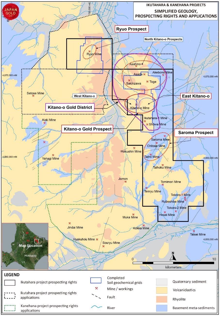
Figure 1: Ikutahara and Kanehana Project areas with simplified geology, main prospects, and the Kitano-o District soil grid outline
To view an enhanced version of this graphic, please visit:
https://images.newsfilecorp.com/files/5665/155731_c79c001434f789f1_001full.jpg
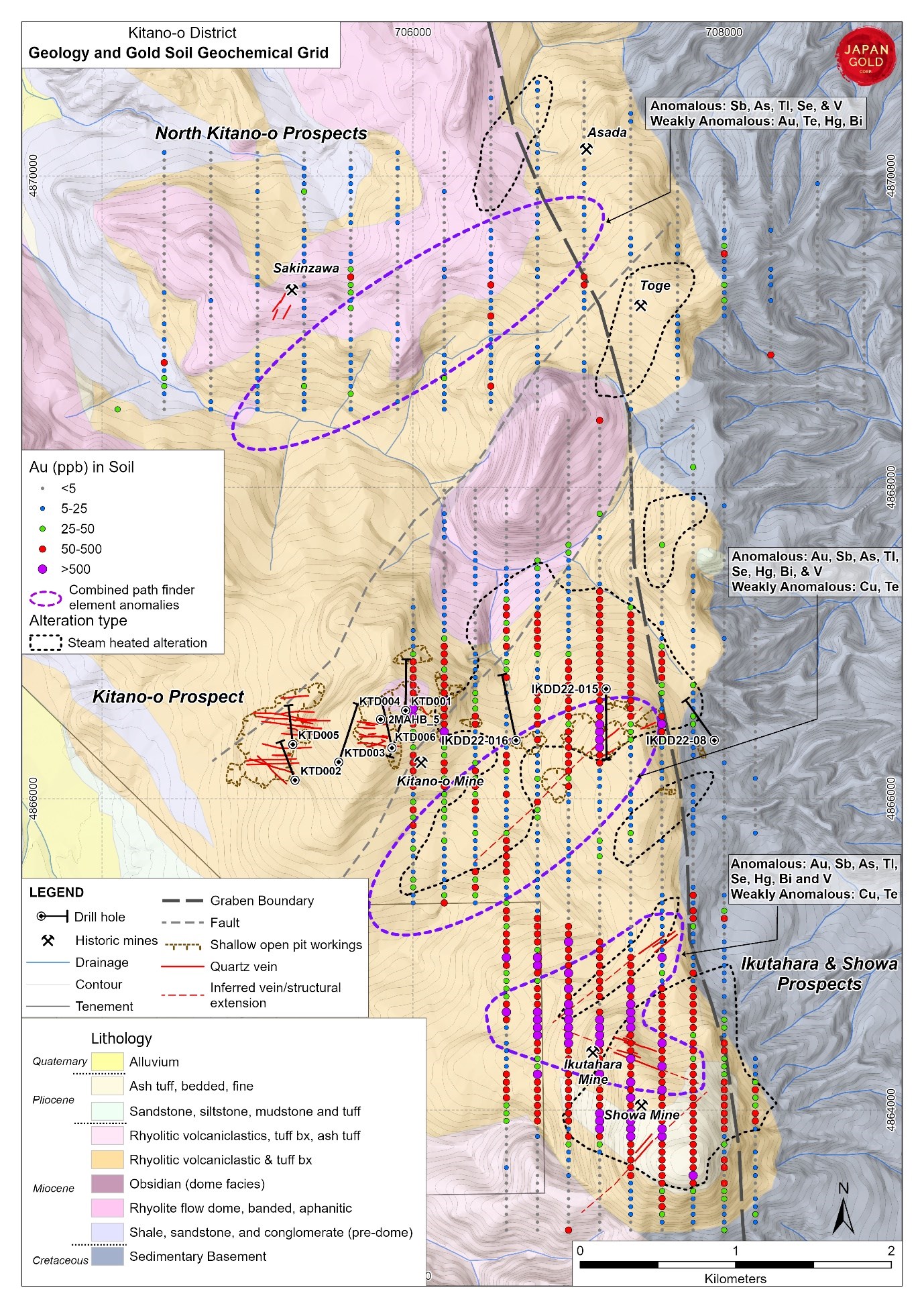
Figure 2: Kitano-o District, geology, gold in soil and combined anomalous zones.
To view an enhanced version of this graphic, please visit:
https://images.newsfilecorp.com/files/5665/155731_c79c001434f789f1_002full.jpg
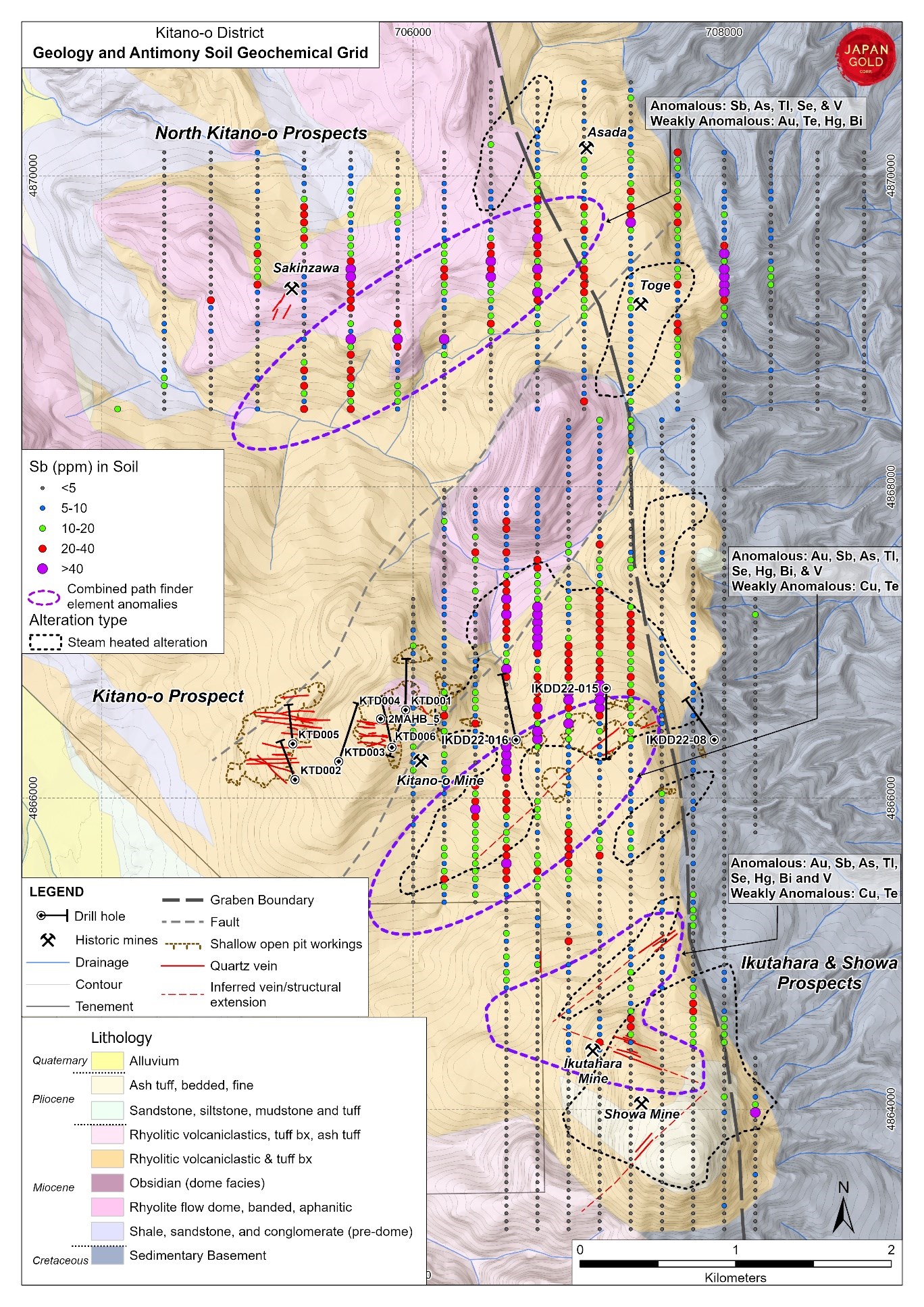
Figure 3: Kitano-o District, geology, antimony in soil and combined anomalous zones.
To view an enhanced version of this graphic, please visit:
https://images.newsfilecorp.com/files/5665/155731_c79c001434f789f1_003full.jpg
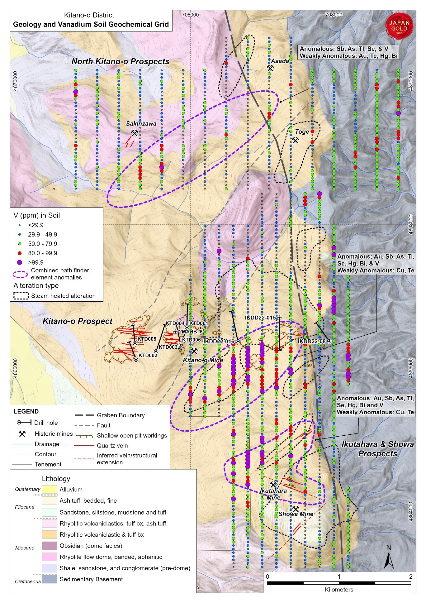
Figure 4: Kitano-o District, geology, vanadium in soil and combined anomalous zones.
To view an enhanced version of this graphic, please visit:
https://images.newsfilecorp.com/files/5665/155731_c79c001434f789f1_004full.jpg
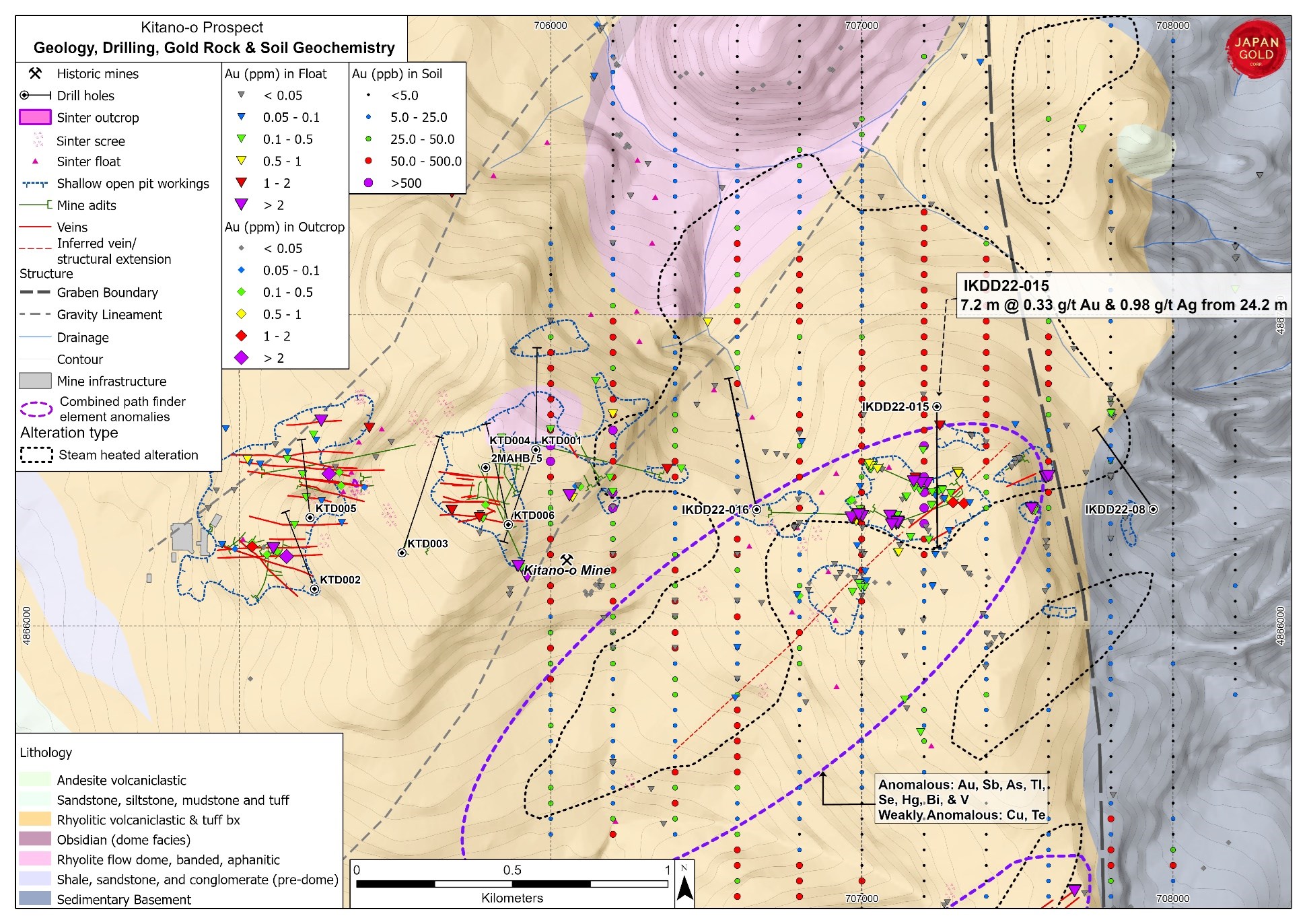
Figure 5: Kitano-o prospect, geology, with gold soil and rock and 2019 and 2022 drill holes.
To view an enhanced version of this graphic, please visit:
https://images.newsfilecorp.com/files/5665/155731_c79c001434f789f1_005full.jpg
![]()
To view the source version of this press release, please visit https://www.newsfilecorp.com/release/155731